Details
Region: Columbia Gorge
Location: town of Mosier, eastern portion of Columbia Gorge National Scenic Area, OR
DEN Rating: 6/10
Trail Length: 5.4 miles total
Trail Type: out and back
Hike Time: 2-3 hours total
Trail Difficulty: moderate 5/10 (easy 3/10 to Mosier Falls)
Elevation Gain: 650 feet
Trail Surface: dirt, rocks, stairs
Popularity: 6/10
Family friendly: yes
Pet friendly: yes-ish (cougars are in the area)
Handicapped Accessible: no
Swimming: yes
Camping: no
Restroom: none
Season: year-round
Pass or Permit: none required
Managed by: City of Mosier and Columbia Gorge Land Trust
Select photographs in this article are available as custom prints. Click on the shopping cart icon to see print media and sizing options. Click on the expand icon for a full-screen view of the image.
Mosier Plateau Trail provides a hike through an environment unlike most in Northern Oregon. Located in an area of transition between the wet forests found west of Hood River and the desert found east of the The Dalles, visitors will discover a beautiful oak parkland and grassland ecosystem offering two great viewpoints plus a brush with local history.
The hike begins in the little town of Mosier. After crossing the road bridge the path begins up the grassy hillside. The wildflower show is incredible beginning in April stretching into June, featuring Balsamroot, Campanula, and blue Bachelor’s Buttons by the hundreds. I was surprised how different the wildflowers were here compared to other locations nearby.
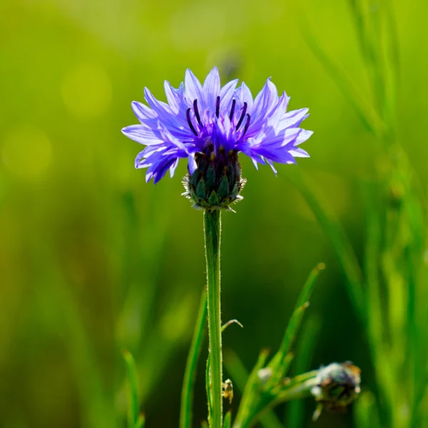
Bachelor’s Buttons are a common wildflower along the Mosier Plateau Trail in the eastern Columbia River Gorge.
Bachelor’s Button
Most people flock to Rowena Crest or Dog Mountain to witness the particularly spectacular springtime burst of yellow balsamroot and purple lupine offered in the eastern stretch of the Columbia River Gorge. Mosier Plateau Trail provides a refreshing alternative with a different and more varied mix of wildflowers, including purple bachelor’s buttons. Rather than photographing … Read more
At the top of the first rise visitors discover the Mosier Pioneer Cemetery, a little plot which includes the resting places of the town founders. Many of the headstones here date from the late 1800’s or early 1900’s.
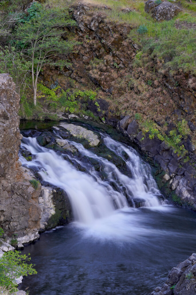
The hike continues along the hillside above Mosier Creek Canyon through beautiful oak woodland. In another five minutes visitors come to a nice viewpoint for Mosier Falls. This 80-foot double-tiered waterfall is quite scenic, especially when the creek is flowing full. An idyllic swimming hole is found between the two tiers, with a prominent rock jutting up that’s perfect for a spot to chill, especially on a hot summer day. This is definitely a popular local swimming and hangout spot. Bring a swimsuit if you’re hiking here June – Sept and jump in! There is a scramble path down to the water.
The hike to the falls is a fairly easy 10-minute jaunt and is well worth it just for the wildflowers, scenery, cemetery, and falls view (and swimming). The trail is wide with dirt surface. However, the falls and swimming hole can also be accessed off 3rd St in Mosier via an old road followed by a 100-foot boot path. There is no parking on 3rd St right by the old road so you’d have to park a little further away and walk up 3rd, but if you’re just trying to get to the falls to swim then this alternate route is shorter and easier.
Beyond the falls the trail gets steeper and narrower, and the trail surface becomes rocky as the trail climbs out of the creek canyon. Stairs and switchbacks lead in a double camel-hump, rising and falling two times. Once out of the creek canyon there is even less shade as the environment becomes more of a grassland. Wildflowers abound! The viewpoint looking out over the Columbia River Gorge is superb. Benches are sparingly scattered throughout the hike.
Overall I really enjoy this hike, particularly the easy section to Mosier Falls. The May wildflower show is dazzling and changes throughout the month. The grass is a beautiful silver-green, and the oaks are picturesque. Expect a decent amount of company on the trail in the warm season. Visiting early in the morning or late in the day if you’re looking for a less busy experience, but be alert due to increased wildlife activity at these times of day.
Note: Measurements vary between sources for both trail length and elevation gain. I averaged them.
Cautions
The lack of shade on hot, sunny days is something to be prepared for. Wear sunscreen, bring lots of water, and rest when needed. This is prime country for ticks and rattlesnakes. I read a post that said a woman’s dog was nabbed by a cougar near the viewpoint at the end of the trail in early May 2023. I encountered a night snake on the trail one evening near the cemetery (they are non-venomous) and I just waited for it to slowly cross the trail. This is definitely a wildlife-rich area. There are a few little clumps of poison oak around near the trail, not bad but definitely present in the area. In the wet season the trail can get muddy and slippery.
Swimming Hole Info
The pool between the two tiers of Mosier Falls is a wonderful and locally popular waterfall swimming hole. The setting is incredible. It’s deep near the base of the upper tier, then shallows a bit before running out of the pool and over the main drop. The water warms up pretty early due to the lack of shade on the water upstream. Do not jump off the cliff into the pool – the water is just not deep enough. Falling off the downstream cliff would be fatal so be careful if you approach the edge. This is not a good swimming spot for young children as there is no safe shallow area.
- summer water temp: comfortable 70-77F
- water clarity: 3-6ft
- color: nondescript greenish to amber (due to oak tannins)
- Depth: 6-10ft
- Current: 1-2
- Shoreline & stream bottom surface: solid rock
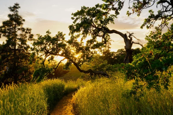
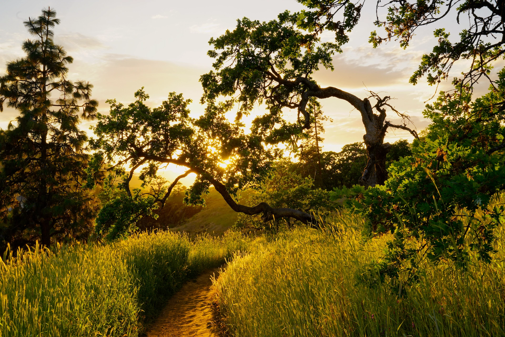
Sunset light catches in the tall spring grass and the leaves of a old, gnarled Oregon oak on the Mosier Plateau Trail in the eastern Columbia River Gorge.
Oaken Evening – Limited Edition
It was a gorgeous spring afternoon in May 2023 when my husband and I ventured into the eastern Columbia River Gorge to see the annual wildflower display. After visiting popular Rowena Crest we decided to hike up the Mosier Plateau Trail to check out the waterfall, a sight we had never seen before. As we … Read more
In stock
Getting There
Take exit 69 off I-84, then head south into town, following the road as it bends left. Park at the gravel parking lot for the day use area on the left before the narrow road bridge. Cross the bridge on foot. The trail begins on the right just past the bridge. You’ll reach Mosier Pioneer Cemetary in 1/4 mile (5 minutes), Mosier Falls Viewpoint in 1/2 mile (10-12 minutes) and the final Columbia River Gorge Viewpoint in 2.7 miles (45-60 minutes).
Photographer’s Tip
The falls face Northwest in a fairly open canyon. You’ll have even shadow across the falls before 8:30 am in spring/summer, and even sun on the falls around midday. In May through mid-August the sunset light streams down the canyon and hits the top half of the falls – no good. However, the sunset light in the oaks and the nice views looking down the canyon are fantastic. Bring a variety of lenses or a versatile camera – there are good opportunities for macro, zoom, and wide-angle shots on this hike. The grass gets quite tall so bring a tall tripod (or a selfie stick) to get pics clear of obstructions.
Links
https://gorgefriends.org/hike-the-gorge/mosier-plateau.html
https://www.alltrails.com/ar/trail/us/oregon/moiser-plateau
https://www.oregonhikers.org/field_guide/Mosier_Plateau_Hike
https://www.pinesnvines.com/adventures/mosier-plateau-hike
https://gorgefriends.org/hike-the-gorge/mosier-creek-falls.html
https://www.wta.org/go-hiking/hikes/mosier-creek-falls
https://www.outdoorproject.com/united-states/oregon/mosier-creek-falls-plateau-trail
https://www.waterfallsnorthwest.com/waterfall/Mosier-Falls-3993