Details
Region: SW Washington
Location: 27781 NE Lucia Falls Rd, Yacolt, WA 98675
DEN Rating: 10/10
Trail Length: multiple trails, varying lengths
Trail Type: out and back, loop
Hike Time: varies
Trail Difficulty: easy 2-3/10, more difficult spur trails
Elevation Gain: 90 ft, most trails less
Trail Surface: dirt, rocks
Popularity: 7/10 (10/10 in summer)
Family friendly: yes
Pet friendly: yes
Handicapped Accessible: yes for some trails, no for others
Swimming: yes
Camping: no
Restroom: flush toilets
Open Hours: day use only (dawn to dusk), gates lock at 8PM
Season: year-round
Pass or Permit: none required
Managed By: Clark County Public Works
Select photographs in this article are available as custom prints. Click on the shopping cart icon to see print media and sizing options. Click on the expand icon for a full-screen view of the image.
For years my friends who lived in Vancouver WA kept telling me to go check out Moulton Falls. They said it was incredible and I would love it. For whatever reason I dismissed all of their advice and just never got around to going. I was a fool. They were absolutely right!
Today Moulton Falls Regional Park is one my favorite places in SW Washington. This beautiful 387-acre park offers access to three waterfalls, three incredible river canyons, and a mile of river access with several jewel-toned swimming holes all set within a robust mixed forest of cedars, maples, alders, and firs. Calendar-worthy Moulton Falls Bridge spans the East Fork Lewis River in a picturesque three-story arch, offering access to the gorgeous emerald clear waters and hiking trails on both sides of the river.
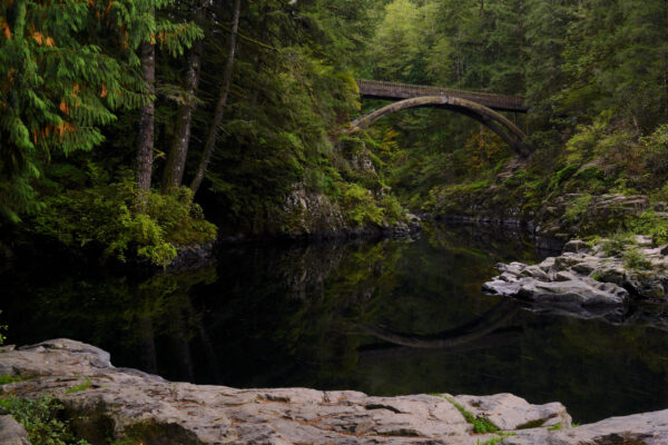
The footbridge over the main canyon at Moulton Falls Regional Park, with its graceful arch and gorgeous setting, is a favorite subject for photographers and selfie-seekers alike. In summer the long pool is filled with swimmers and folks on floaties.
Autumn Bridge
This perfect arching footbridge is the centerpiece of Moulton Falls Regional Park on the East Fork Lewis River in SW Washington. This shot was taken just after sunset on an early October evening. I love how the warm afterglow of sunset light tints the entire shot, bringing out the emerging autumn colors as well as … Read more
Unfortunately, Moulton Falls is well-known and can become extremely crowded on summer weekends, to the point where the parking areas are completely full. During the wet season and on weekdays in the warm season you will be able to find parking. I tend to visit on summer weekdays in the late afternoon/evening and have always had a good experience to where the park does not feel crowded and there’s plenty of parking.
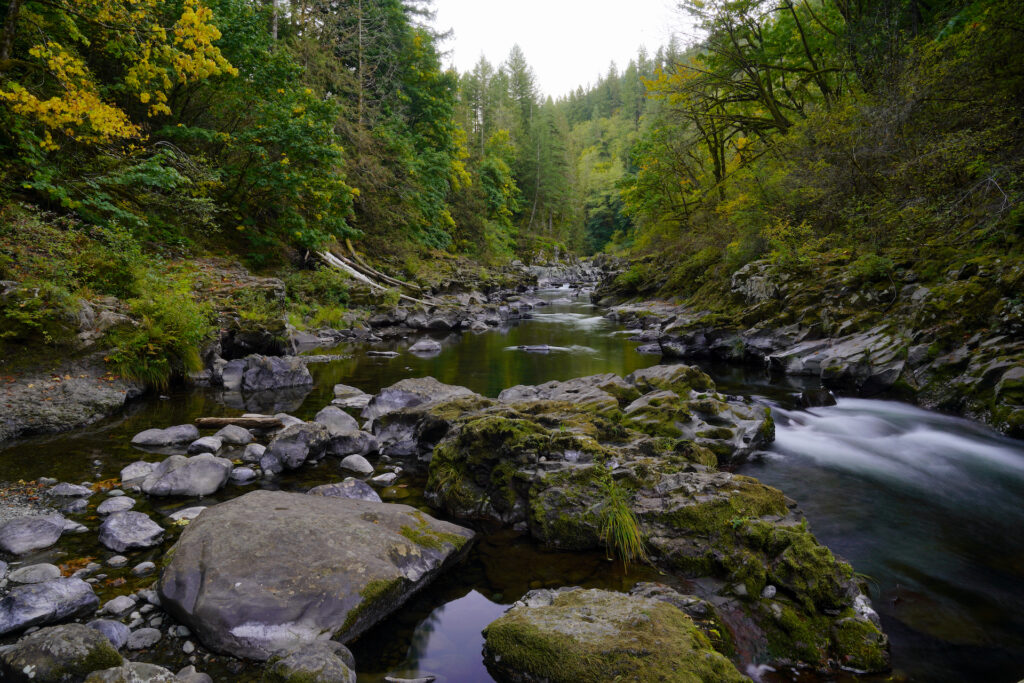
My favorite part about this park is it’s size. It is quite large and includes a variety of trails for every skill level. The swimming holes are equally varied as well; from shallow beaches perfect for young children to wade in, to deep pools flanked with low rocks perfect for your pool floatie, to cliff jumps into the base of a waterfall, you’ve got it all in one park. The forest is quite pretty too – lush and tranquil. The other cool thing about this area is the incredible geology, with volcanic rocks worn smooth by the river over a million years, pitted and sculpted into amazing shapes.
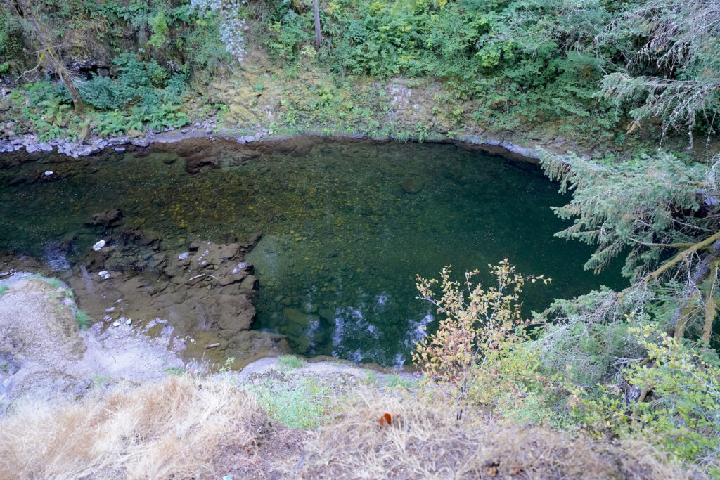
Naked Falls is a beautiful hidden oasis upstream of Moulton Falls Regional Park on the East Fork Lewis River, not to be confused with the better-known falls of the same name on the nearby Washougal River.
Naked Falls 1
Incredibly beautiful Moulton Falls Regional Park has loads of amazingly photogenic scenes within it. I had heard of Naked Falls and so one afternoon I trekked upstream beyond the park hoping I would find it. After some exploring, a steep scramble up a slope, and a few logs to climb over I arrived at this … Read more
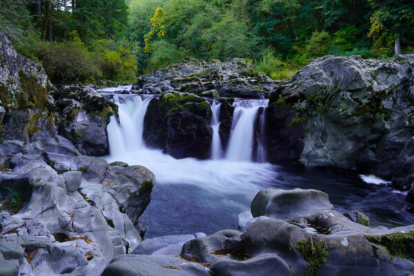
Moulton Falls has three parking areas. Most visitors drive upstream on Lucia Falls Rd to reach Moulton Falls Park, reaching the main (downstream) parking area first. This parking area gives immediate access to 11-foot Moulton Falls itself. The main trail heads downstream (right) down a flight of stairs and onto the rocks around Moulton Falls. The falls are not that impressive to look at – it’s hard to get a clear view because of the way the canyon twists and it’s more of a big steep rapid than a falls, but the cliffs below the falls are heaven for jumpers, offering leaps of 15-25 feet into the deeply carved canyon below the falls. Sadly there is some graffiti on the rocks around the falls. Why??? Depending on how far you go and how wet the rocks are, accessing the rocks around Moulton Falls are 3-6/10 in difficulty.
There is a small piece of private property just upstream of the main parking lot along the river. To get to the rest of the park visitors must either wade up the river (the land is private property and there’s no good way through the brush) or walk along the road about 100 feet until a path opens up going down into the park and crossing Big Tree Creek. The nicest shallow beach for little ones is here where the creek joins the river although it is pretty small. Continue on the path to the park restrooms and the little seating area by the river. This route is the flattest and best for handicap access to the park restrooms – an easy 2/10 in difficulty.
If you continue past the first parking lot there are two more parking options. I prefer the second parking area, labeled Moulton Falls Overflow Parking. Take the big main trail leading down from the SW corner of the parking lot next to the handicap parking space. You will soon reach a big trail junction. Go right (downhill) to reach the park restrooms, seating area, and to reach the main parking area and Moulton Falls. From the seating area head upstream along the riverbank to the big open rocks – this is where you blow up your floatie, take a refreshing swim, and get some pics of graceful Moulton Falls Bridge reflected in the river. I would rate the trails out of the overflow parking as 3/10 as they are a little steeper.
The left trail leads uphill to the bridge, with stunning views of the gorgeous canyon upstream of the bridge and the open pools below. Continue over the bridge to find two picnic tables and steep scramble paths leading down onto the rocks along the river. Stay on this main trail to reach Bells Mtn trailhead in 1/2 mile, Chelatche Prairie Railroad lake & picnic area in 1.75 miles, and Hantwick Road Trailhead in 2.25 miles (restrooms at trailhead). This trail follows an old road and the railroad tracks and is very well graded, following alongside the river for much of it’s length. It’s very pretty and is popular with runners, an easy 2/10 in difficulty with two short steeper sections at a 5/10.
There are often teens jumping from the bridge in the summer. There have been a few deaths and serious injuries. Part of the danger is accidentally landing on a swimmer below. There are big signs warning people not to jump, and those who do can be ticketed. There are plenty of other great jumps in the park…don’t be an idiot!
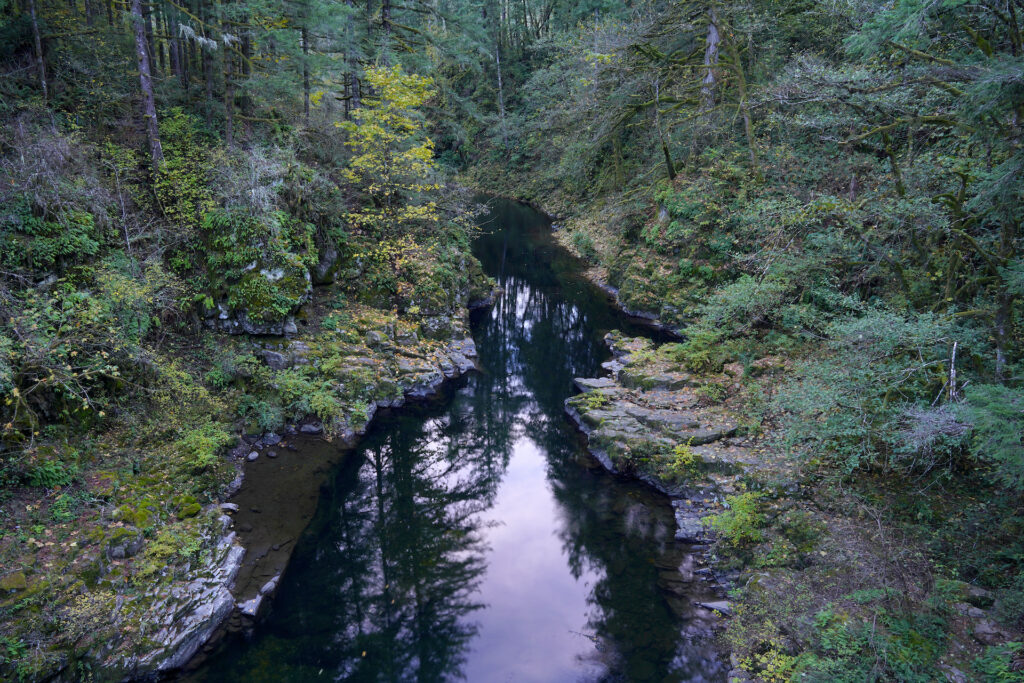
If you’re up for a little more adventure, try exploring upstream of the bridge to find several more swimming holes. Instead of crossing Moulton Falls Bridge, turn left just before the bridge and follow the smaller trail along the clifftop (it’s got strong cable guardrails so no worries about falling). Within a few minutes you’ll reach the Upper Canyon Overlook at a five-way trail junction, with a small circle trail providing views of the river looking upstream from above. Another trail heads back into the forest (take a hard left), passing several picnic tables, then connects to the main trail near the overflow parking area.
If you with to explore further upstream beyond the park boundaries, the main trail continues downhill to the left at a more moderate 4/10, with two spur boot trails both bearing right toward the water – both access the rocks and swimming hole at the top end of the Moulton Bridge Canyon (the first is shorter, the second is easier). Or continue on the main trail, weaving down onto the rocks and along the edge of the forest for another 1/4 mile before reaching a steep gravel beach with a nice swimming hole at the downstream end of yet another canyon.
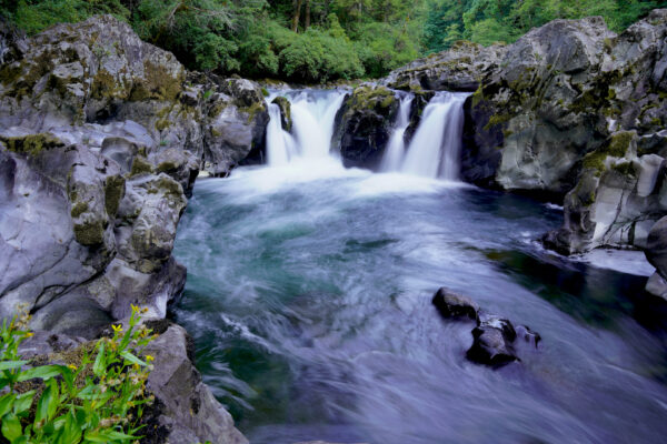
Little bubbles trace the gentle current of East Fork Lewis River in SW Washington. The uppermost beach is out of the shot on the left. What an absolutely gorgeous place!
Going With The Flow
Little bubbles trace the gentle current of East Fork Lewis River as it flows through a rocky canyon just above Moulton Falls Regional Park in this long exposure photo. The autumn leaf transformation is kicking off in the forest above the rocky walls. What a sublime spot! To visit Moulton Falls Regional Park: Moulton Falls … Read more
The trail continues, scrambling up a more difficult steep boot path with about 30 feet of elevation gain (7/10), then levels out as it passes through the forest behind the canyon rim. You’ll go over and under a few logs, then descend down mossy stone steps to discover the hidden gem of the Moulton Falls Park area – Naked Falls. This pretty waterfall drops 10 feet into a swift pool with a cascading 4-foot drop above it and a swirling chute below. The rocks here are particularly sculpted into ghoulish, otherworldly shapes, and are pretty smooth and slippery so mind your footing. Chances are, if you make the short trek to Naked Falls you will be rewarded with a gorgeous waterfall all to yourself!
The forest is just beginning its autumn transformation behind Naked Falls in SW Washington, as seen in the late afternoon shadow of a pleasant day in early October 2023.
Naked Falls 4
The forest begins it’s autumn transformation behind Naked Falls on East Fork Lewis River in SW Washington. Getting to this hidden waterfall takes a little scrambling but the reward is supremely worth it. This view is head-on, capturing both the oddly-sculpted rocks which surround the falls in the foreground and looking back up the forested … Read more
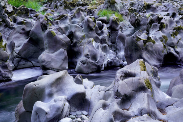
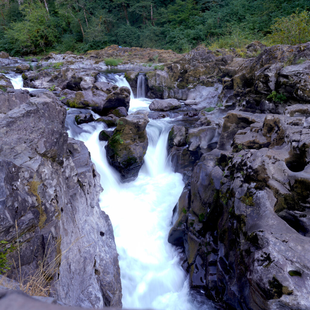
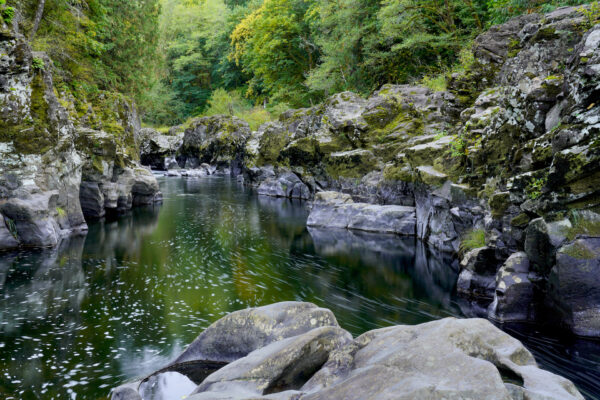
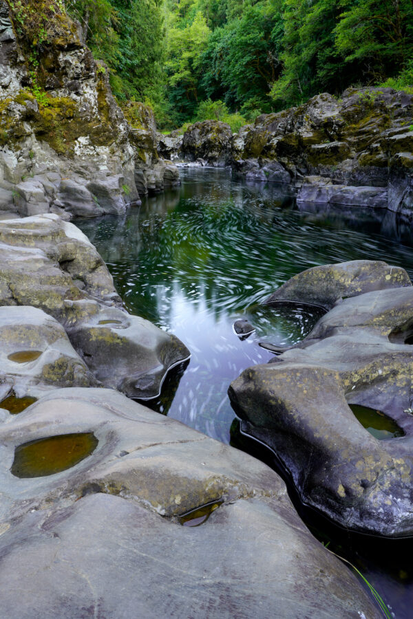
East Fork Lewis River shows the extremes of river rock sculpting just below Naked Falls, creating strange and ghoulish forms. Be careful as the rocks are very smooth and slippery.
Sculpted Stone
East Fork Lewis River took some psychedelics and went to town on it’s shallow canyon below Naked Falls, sculpting the rocks into some of the coolest, most wicked-looking formations I’ve ever seen. The many pockets, fins, and protrusions, worn smooth by time, have a ghoulish, grotesque air about them. The long exposure illustrates the swiftness … Read more
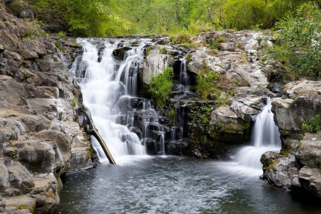
The third parking area is best for a quick visit to the park’s prettiest waterfall. It’s along the road next to the creek at the three-way intersection of Lucia Falls Rd, Railroad Dr, and Sunset Falls Rd. A trail leads down from the crosswalk to views of 28-foot Yacolt Falls (also called Big Tree Creek Falls) in less than 200 feet. Cross the bridge (it is sometimes closed) for the clearest views of the falls. In summer this falls and its smaller swimming pools feel intimate compared to the grandiosity of the Lewis River canyons in the park, but in the winter Yacolt Falls becomes a powerful and thundering sheet of water and honestly steals the show. There are two swimmable pools here – one below the main 22-foot falls, the other below the bridge and it’s little 6-foot second cascade. The water is a few degrees colder in Big Tree Creek than it is in the river so plan your swimming accordingly. The trail continues up stone steps, then increases in difficulty as it descends through the forest before crossing the road and connecting up with the main park trail near the confluence of Big Tree Creek with the river, close to the main (lower) parking area. You can also scramble around the creekbed above and on the right side of the falls. Unfortunately a tree has fallen in on the right side of the falls but it’s not a huge detraction, although it has blocked off a soaking pool and made accessing the creek above the falls are little more challenging.
For me Moulton Falls Regional Park is a top-notch spot. With a huge diversity of offerings and several points of interest, Moulton Falls offers something for everyone. On a summer day it would be easy to bring a lunch and spend the entire day here. In autumn the colors are superb. In spring the waterfalls are gushing and the forest floor is alive with flowers. And in winter the park offers several miles of wonderful hiking trails when other higher-elevation trails and roads are closed. One visit and I’m sure you’ll agree that my friends are right – Moulton Falls is not to be missed!
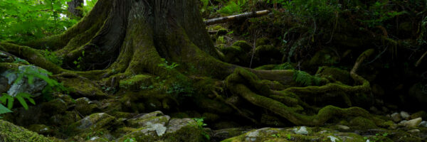
Pretty sure that trolls, fairies, and possibly a wicked witch live somewhere near the dark roots of this hemlock tree near Naked Falls just outside Moulton Falls Regional Park.
Cautions
The main trails in the park are all easy 2 or 3 out of 10, so as long as you stay on the main trails there are very few dangers. I have never seen any poison oak at Moulton Falls so there’s another thing you don’t have to worry about. The biggest danger is slipping on rocks. The rocks are really cool and fun to explore, but they are smoother than they appear and can be very slippery especially when wet (or when your shoes are wet). If swimming, stay where the current is gentle. If you are jumping in, make sure it is deep enough first! Just follow the general rule of knowing your abilities and limits. Absolutely do not jump off Moulton Falls Bridge – a jump from the bridge ended in a tragic fatality here in 2018.
Swimming Hole Info
The park’s main swimming hole is downstream of the bridge – access the rocks by finding the park restroom then heading upstream about 100 feet along the shoreline. It has only the slightest current and extends upstream under the bridge and through the incredible canyon for a considerable distance. There are lots of 3-10ft jumping rocks. Continue upstream beyond the bridge to find additional, smaller, more private swimming holes and small beaches but few jumping rocks. Naked Falls is not really suitable for swimming – the current is pretty strong in the pool and it’s hard to tell how deep it is due to all the bubbles in the water. Below Moulton Falls is a deep canyon studded with 15-25ft cliff jumps that the teen hotdoggers can’t get enough of — climbing out takes some creativity. Yacolt Falls features two nice pools, with the upper pool at the base of the falls being deeper and a little easier to access. There are a few possible 3-10ft jumps here if you scramble out onto the ledges in the middle of the falls.
East Fork Lewis River:
- summer water temp: cold 60F-67F
- water clarity: 6-10ft, sometimes more
- color: clear teal green
- Depth: 10-20ft, deeper in a few pockets. Upstream smaller pools are shallower 6-10ft.
- Current: 0-1 at main swimming hole below bridge, 1-3 at upstream pools, 2-4 below Moulton Falls
- Shoreline & stream bottom surface: rock slabs with a few pebbly beaches. Bottom surface is pebbles and larger rounded rocks.
Yacolt Falls:
- summer water temp: cold 55-63F
- water clarity: 3-6ft
- color: dark, somewhat colorless
- depth: upper pool 10-20ft, lower pool 6-10ft
- current: 0-1, very gentle
- Shoreline & stream bottom surface: solid rock around upper pool, rounded river stones around bottom pool and on the bottom of both pools.
The rock formations get really interesting in the short canyon below Naked Falls on East Fork Lewis River. The long exposure helps to show not just how the current flows through this gorgeous canyon, but also where the current speeds up. The bubbles are generated by Naked Falls which is just out of the shop upstream. In summer this is an idyllic swimming holes with many possible rock jumps in the 5-20 foot range…always check the water depth before jumping to avoid hidden rocks and ledges lurking beneath the water surface.
Swirling Through Stone
East Fork Lewis River may not have the well-known thundering waterfalls of it’s North Fork sibling, but it has some of the most weird and interesting rock formations I’ve ever seen along with gorgeous dark teal water. The end of this short canyon below Naked Falls is particularly photogenic, especially when photographed using a long … Read more
Getting There
From Battle Ground WA, follow WA-503 north for about 5 1/2 miles, then turn left onto NE Lucia Falls Rd. Enjoy this beautiful drive for 8 1/4 miles to the main parking lot, 8 1/2 miles to the overflow lot and Yacolt Falls parking. Alternatively it is a 2 1/2-mile drive south on Railroad Ave from the town of Yacolt.
Photographer’s Tip
Ignore Moulton Falls. Focus on the arch bridge, Yacolt Falls, the cool volcanic rock shapes in the rocks, the pools in the river, and the lovely forest. Yacolt Falls faces south and is in full sun around mid-day so bring a neutral density filter if it’s sunny. Naked Falls faces north and is in an open canyon, so expect backlighting on sunny days. By 5pm in summer all of the major attractions (bridge, Yacolt Falls, Naked Falls, and the canyons) are all in even shadow. The water is more reflective near dawn and dusk, and you see more deeply into the water around midday – a polarizing filter is quite handy to reduce reflections if that is your aim. A variety of lenses could be useful in this park. For Yacolt Falls you’ll want a 24-70mm lens.
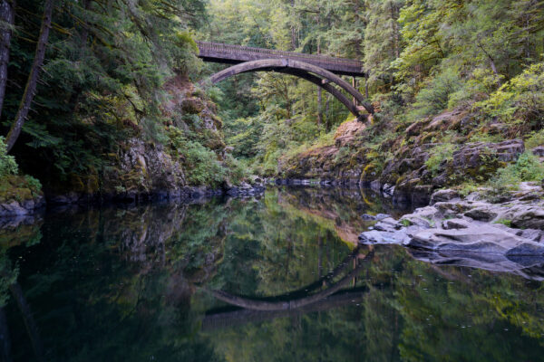
Morning is a great time to photograph the picturesque footbridge in Moulton Falls Regional Park while the park is not yes busy.
As Above So Below
The foot bridge crossing the East Fork Lewis River graces the canyon in Moulton Falls Regional Park. This part of the park is very popular – both the bridge and the swimming hole beneath it are full of people on summer afternoons. But morning provides visitors with a quiet moment and fantastic lighting to capture … Read more
Links
https://clark.wa.gov/public-works/moulton-falls-regional-park
https://www.alltrails.com/parks/us/washington/moulton-falls-park
https://www.wta.org/go-hiking/hikes/moulton-falls#hike-full-description
https://www.oregonhikers.org/field_guide/Moulton_Falls_Hike
https://www.waterfallsnorthwest.com/waterfall/Moulton-Falls-5208
https://www.waterfallsnorthwest.com/waterfall/Yacolt-Falls-4859
https://www.outdoorproject.com/united-states/washington/moulton-falls