Details
Region: Central Oregon
Location: 32651 OR-19, Kimberly, OR 97848 (Thomas Condon Visitors Center)
DEN Rating: 9/10
Trail Length: multiple trails, distances vary, most are less than 1/2 mile.
Trail Type: several loop trails, some out and back.
Hike Time: varies, most 30 minutes or less.
Trail Difficulty: varies, most are easy 2-3/10
Elevation Gain: varies
Trail Surface: mostly dirt. A few are paved or boardwalk.
Popularity: 3/10
Family friendly: yes
Pet friendly: yes except Blue Basin
Handicapped Accessible: yes at a few locations, no on most trails
Swimming: no
Camping: no official campground, dispersed camping at some locations
Restroom: vault toilets, flush at Visitors Center
Open Hours:
- Visitors Center: 10AM – 4PM Friday – Monday (closed Tues, Wed, and Thurs)
- Trails: open 24 hours
Season: year-round
Pass or Permit: none required
Managed By: National Park Service
Select photographs in this article are available as custom prints. Click on the shopping cart icon to see print media and sizing options. Click on the expand icon for a full-screen view of the image.
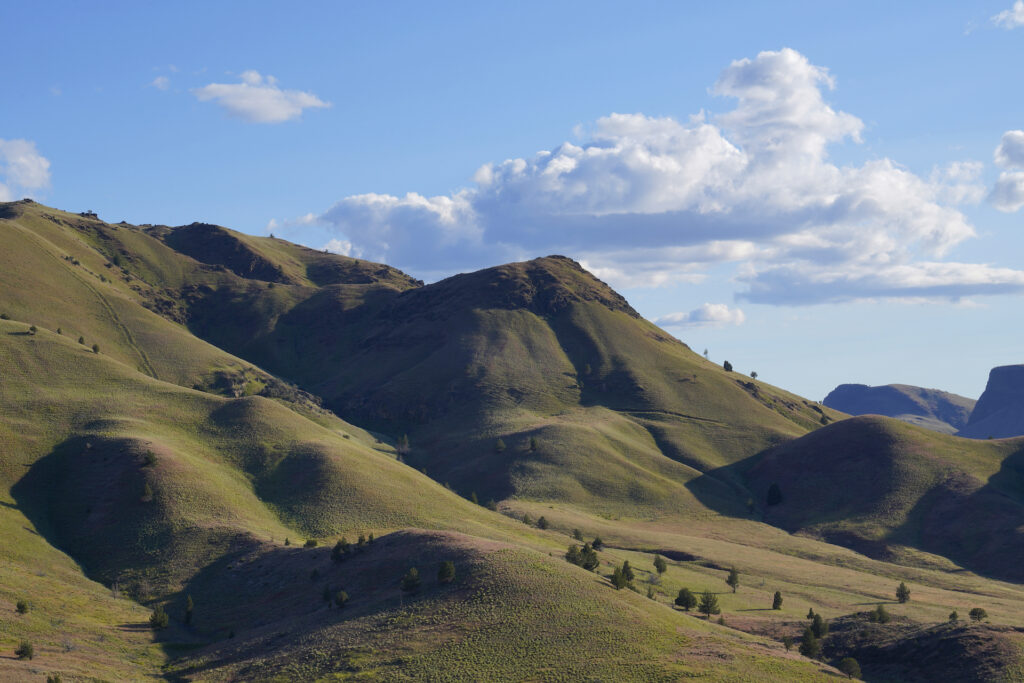
John Day Fossil Beds National Monument is one of the greatest parts of Oregon. Comprised of three separate units, each with it’s own flavor, visitors have the opportunity to witness the past captured in stone. The beautiful, semi-arid environment is not exactly a desert, but it’s also a far cry from the wet forests and valleys found west of the Cascades. With over 14,000 acres of clear, open views, incredible trails loaded with geological history, fascinating scenery, and very few visitors, John Day Fossil Beds is an outstanding example of what makes the Pacific Northwest such a diverse and beautiful natural wonderland.
Fossil history in the park’s three units goes back 40 million years to the time of early mammals. Various layers have become exposed over the millennia, with each one providing a window into the ecosystem of the area at the time. Plant and animal fossils have been recovered at several sites, revealing some incredible inhabitants of a time when things were quite different than they are today. Each of the three units highlights different facets of these ancient times, presenting this natural history in visually captivating ways. Be aware that collecting fossils and minerals is strictly prohibited anywhere inside the National Monument, and that stepping on the formations damages them easily so please stay on the well-marked trails.
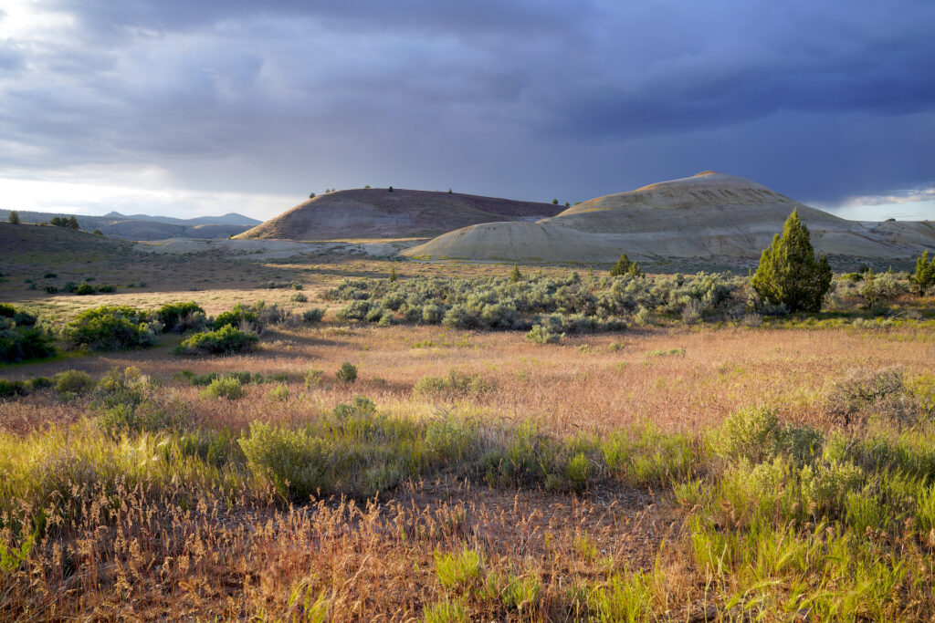
Unfortunately there were several large grass and forest fires near all three units in summer 2024, including one that came very close to Painted Hills. You’ll see burn scars all around, particularly when driving between units. Some area campgrounds may be closed as a result.
The sections below provide more detail about each location within the three units of John Day Fossil Beds: Sheep Rock, Painted Hills, and Clarno. Each unit includes multiple trails. Be aware that each of these units is over an hour drive from the others, and the entire area, while it has mostly good roads, is quite remote. Planning your visit and being prepared to be in places with minimal development or services will make your experience far more enjoyable. To help you get the most out of your visit I created a few itinerary options which are near the bottom of the article.
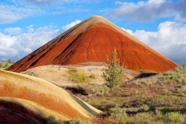
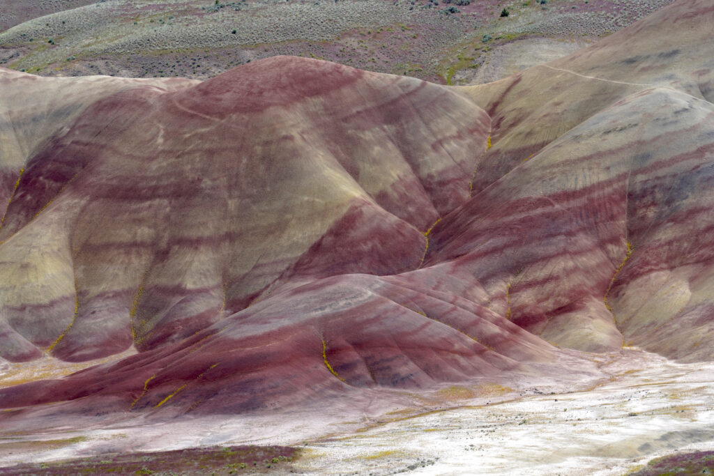
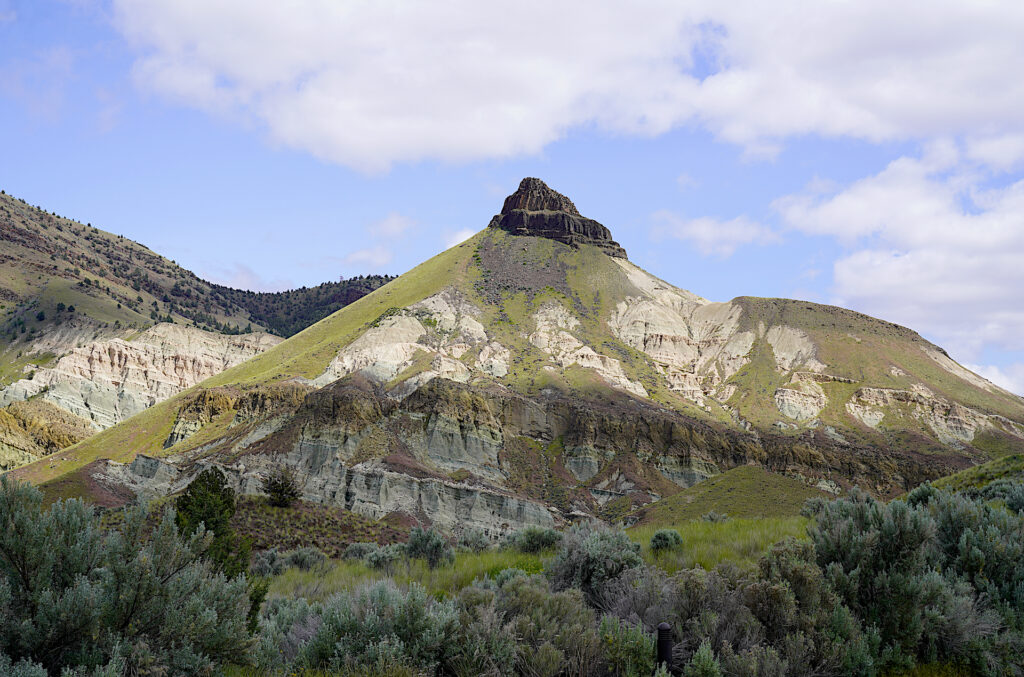
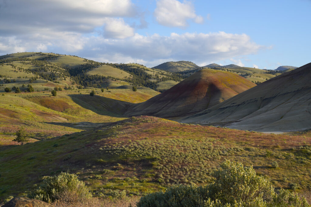
Red Hill stands proudly beneath drifting clouds in the Painted Hills Unit.
Red Hill 5
Red Hill stands boldly beneath drifting clouds on a May afternoon. The perfect form, smooth sides, and deep color combine to create a beautiful focal point. The striped mound in the foreground adds a lot of interest as well. To visit John Day Fossil Beds: https://denphototravel.com/2024/john-day-fossil-beds-national-monument/
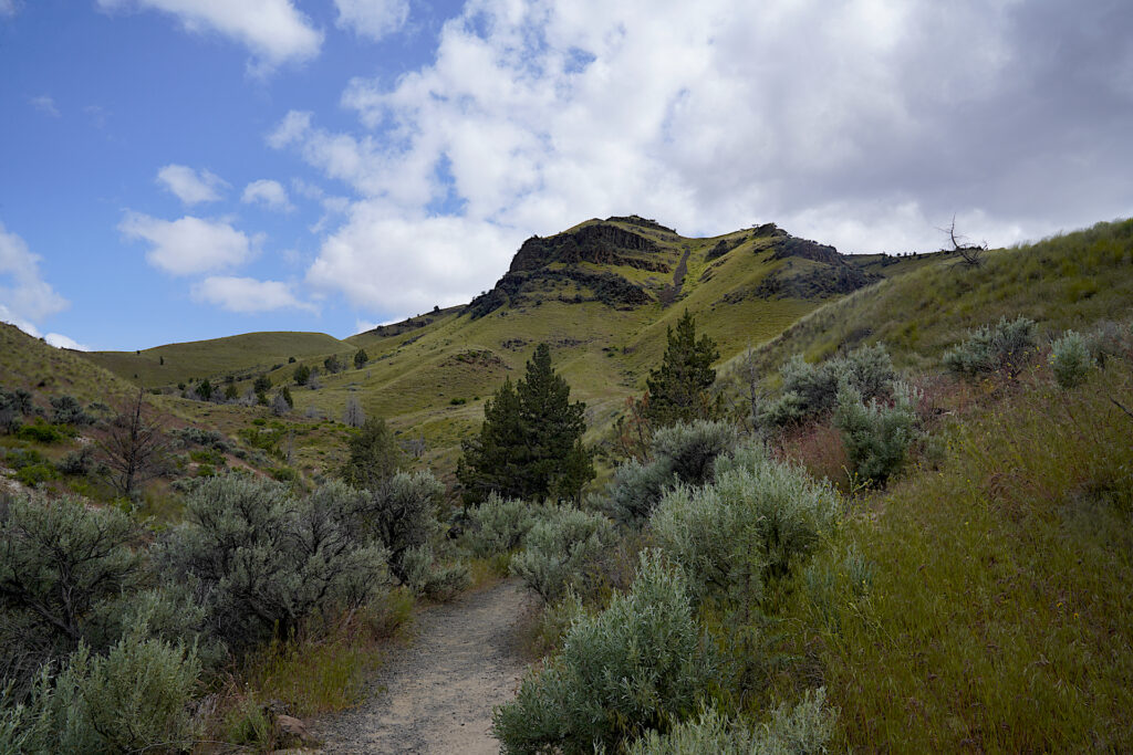
Sheep Rock Unit
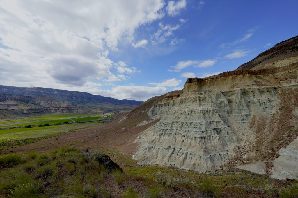
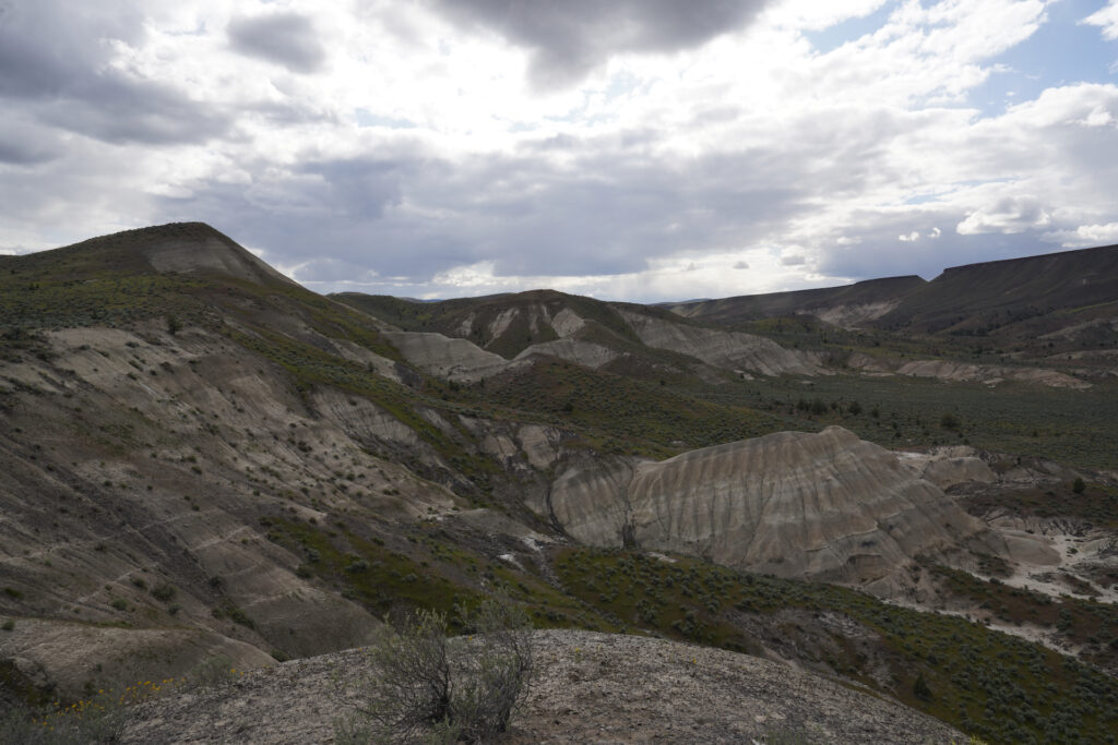
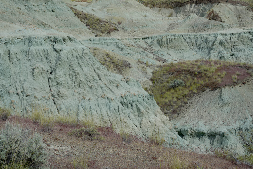
The Sheep Rock Unit is the largest of the three. It houses the headquarters for the National Monument as well as the superb Thomas Condon Visitors Center and a dozen trails and viewpoints. Fully exploring this unit, with it’s signature mint green celadonite claystone, takes the better part of a day. I was quite surprised, thankfully so, to find the vast majority of the locations at Sheep Rock nearly to completely empty, even though we were visiting on a Sunday in May with perfect weather.
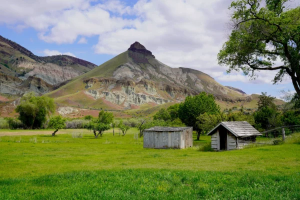
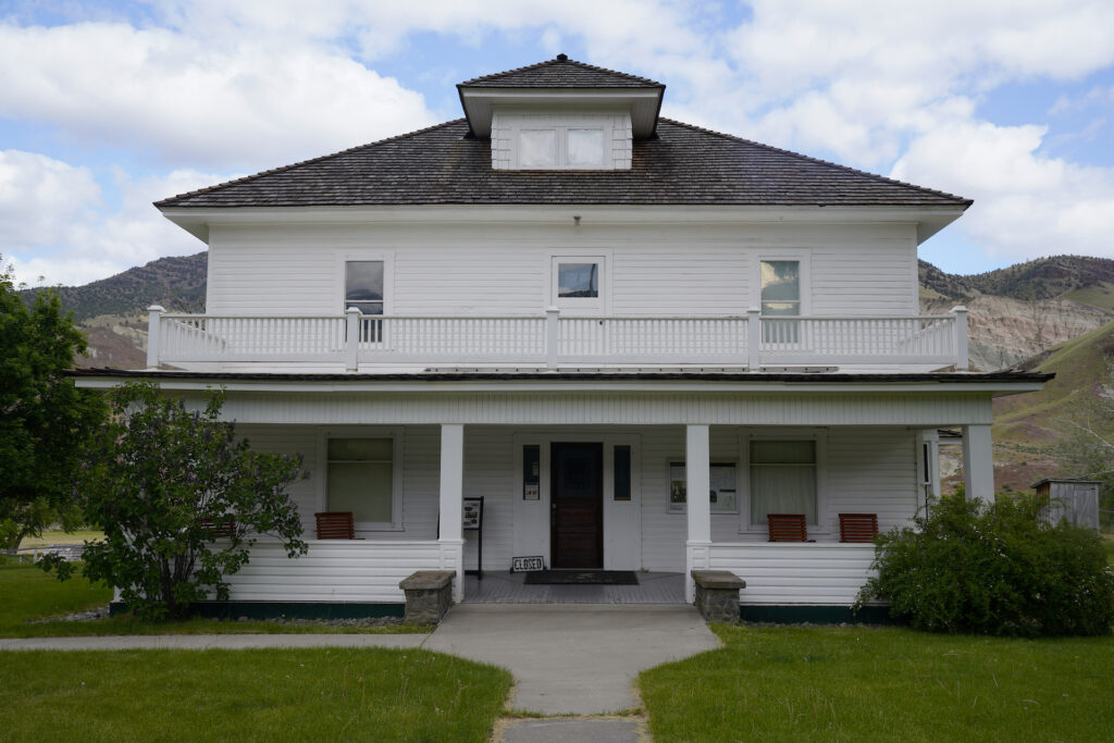
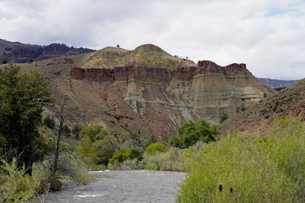
Sheep Rock, with it’s pointy basalt top and layers of eroding green claystone below, forms a perfect backdrop for the green fields and little wooden sheds at historic Cant Ranch.
Cant Ranch At Sheep Rock
Sheep Rock, with its pointy basalt top and layers of eroding green claystone below, forms a perfect desert backdrop for the green fields and little wooden sheds at historic Cant Ranch in John Day Fossil Beds National Monument. Visiting here felt like stepping into an old Hollywood western and I wanted that feeling to come … Read more
Thomas Condon Visitors Center
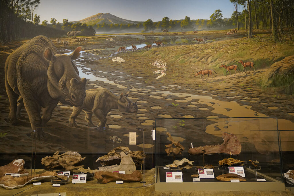
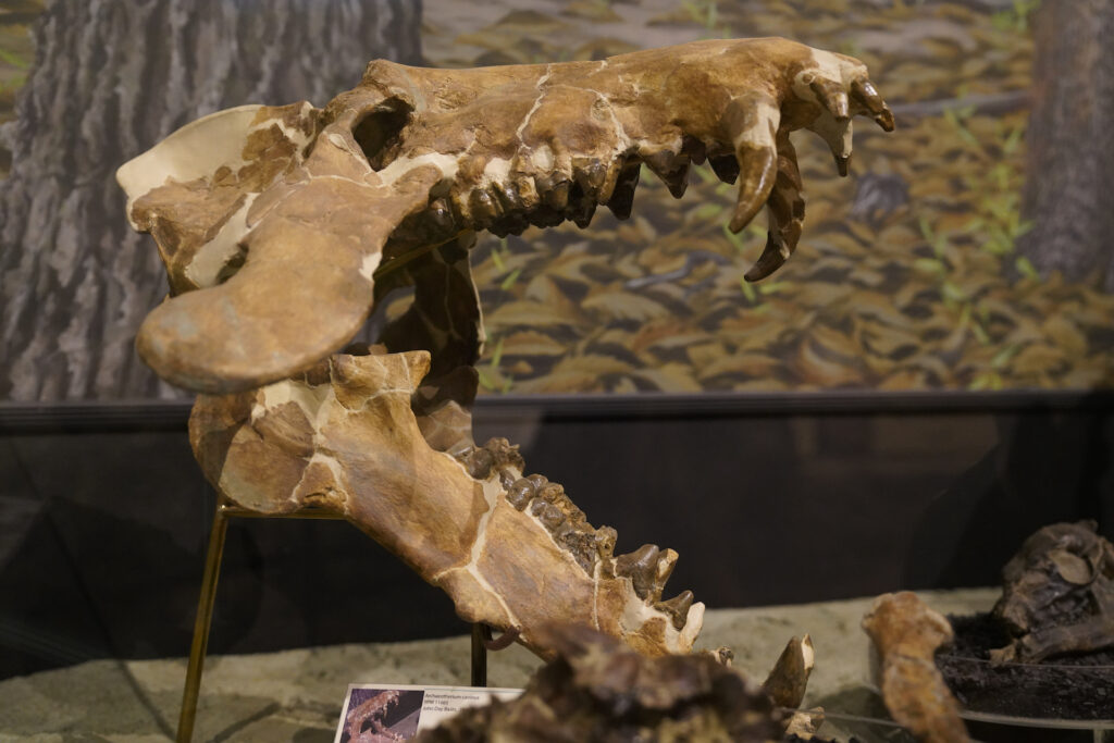
Arguably the best place to begin a vist to John Day Fossil Beds is at Thomas Condon Visitors Center, where visitors can learn about the various earth layers and check out fossilized prints and skeletal remains of the area’s inhabitants from eons ago. There is a surprisingly large amount of beautifully presented material on display. The best part – it’s free to enjoy! The center also includes a theater showing a 20-minute film on the park’s geologic history as well as a working paleontology lab viewable through a big window in the lobby. The staff at the main info desk were all quite friendly and helpful. The flush toilet restrooms, located in a separate building at the entrance, were very nice and clean – a welcome relief after a long drive and also the only ones you’ll find. You will also find the only wifi in the park here, with signal inside the building and in the entrance plaza. The Visitors Center is great for kids and is ADA accessible. Plan to spend 45-90 minutes here, plus time to stroll down the Condon Overlook Trail.
Condon Overlook Trail
- Trail Length: 0.25 miles total (1/8 mile each way)
- Trail Type: out and back
- Hike Time: 5-15 minutes
- Trail Difficulty: easy 2/10
- Elevation Gain: 40 feet
- Trail Surface: dirt and gravel
- Popularity: 3/10
- Family friendly: yes
- Pet friendly: yes
- Handicapped Accessible: no
Short and sweet, Condon Overlook Trail leads from the parking lot at Thomas Condon Visitor Center and out to an overlook of the John Day River valley with dramatic Sheep Rock towering in the near distance. Get your most up-close shots of Sheep Rock here.
Cant Ranch
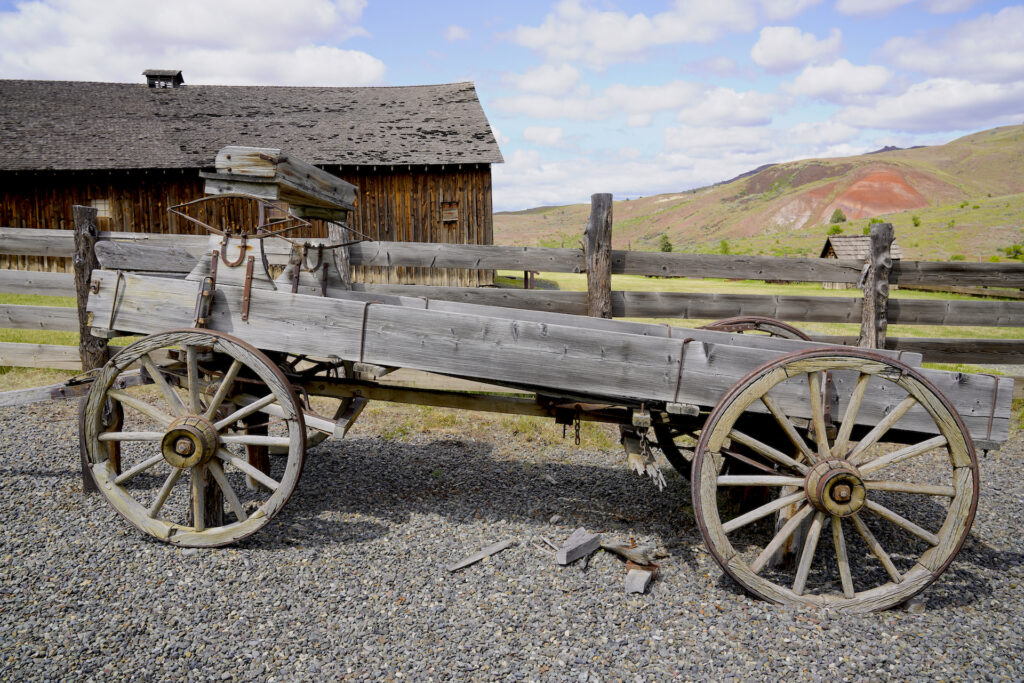
Just north of the Thomas Condon Visitors Center, Cant Ranch provides a quite different look at the life and times of local residents. Instead of layers of earth revealing the secrets of ancient life, here visitors can step back in time to the early 20th century at the homestead of Scottish settlers James and Elizabeth Cant who made the beautiful John Day River Valley their home for decades. The well-preserved ranch house now serves as the park headquarters with a museum on the ground floor featuring exhibits from local indigenous people plus items from the Cant family’s settlement and daily life on the ranch. Unfortunately the museum is open infrequently and irregularly due to low staffing availability. It is handicapped accessible. A short and easy trail leads around and through several detached historic buildings and explains the workings of the ranch from a century ago. If you’re interested in the human history of the John Day area, this is where you’ll discover it. Full exploration of the museum, ranch, and the two trails takes 60-90 minutes.
Sheep Rock Overlook Trail
- Trail Length: 0.6 miles total (0.3 mile each way)
- Trail Type: out and back
- Hike Time: 10-20 minutes
- Trail Difficulty: easy 2/10
- Elevation Gain: 59 feet
- Trail Surface: dirt and gravel
- Popularity: 1/10
- Family friendly: yes
- Pet friendly: yes
- Handicapped Accessible: yes-ish
Starting at the front gate of the Cant Ranch House, this short and easy trail heads south to a fantastic overlook with Sheep Rock in the distance and the John Day River running past. Personally I like this overlook better for pictures than the one at the visitors center because the river makes such a picturesque foreground addition. While the trail is not labeled ADA accessible, it is wide with a good surface and gentle, even grade, and could be doable in a wheelchair depending on your specific situation.
River Trail
- Trail Length: 0.5 miles total (1/4 mile each way)
- Trail Type: out and back
- Hike Time: 10-20 minutes
- Trail Difficulty: very easy 1/10 (final few feet to river are 2/10)
- Elevation Gain: 6 feet
- Trail Surface: paved, boardwalk, dirt and rocks
- Popularity: 1/10
- Family friendly: yes
- Pet friendly: yes
- Handicapped Accessible: mostly yes
The River Trail at Cant Ranch heads down to the river via an improved trail from the parking area. The path skirts around a lawn and field, then turns and becomes a boardwalk as it parallels the river, passing an old orchard which still bears fruit (yes you may pick and eat it!). At the end of the trail a footpath leads through brush to the river’s edge, which features a fantastic view of Sheep Rock. The trail is wheelchair accessible to the end of the boardwalk.
Blue Basin
Two trails, the two longest and steepest in this unit, lead from the Blue Basin parking area. Vault toilets and picnic tables are available at the parking area. There are fifteen bridges with rough metal grating surfaces on these trails which can be painful for dogs to cross. While dogs are allowed, the reality is that the two trails here are the only ones in the entire John Day Fossil Beds National Monument which are not so fun for your fur baby! We had three chihuahuas with us and we carried them across the first bridge. Ultimately we turned back after about seven minutes and did not complete these hikes because we got a late start and had so much more to see that the added difficulty with the dogs made these hikes not worth it for us. Completing these hikes is definitely on my list because the area was incredibly beautiful, particularly when we visited in spring. If you’re exploring both trails plan to spend three hours at Blue Basin.
Island In Time Trail
- Trail Length: 1.3 miles total (0.65 miles each way)
- Trail Type: out and back
- Hike Time: 30-50 minutes
- Trail Difficulty: moderate 4/10
- Elevation Gain: 252 feet
- Trail Surface: dirt and gravel with metal grate bridges
- Popularity: 5/10
- Family friendly: yes
- Pet friendly: yes but not advised
- Handicapped Accessible: no
Island In Time Trail is one of the coolest trails in the National Monument and the most popular in this unit. The trail leads up alongside a drainage gully into a basin where visitors are surrounded by green claystone badlands of the Turtle Cove Formation. Look for plexiglass bubbles protecting the fossilized skull of a false saber-toothed cat and another of an ancient wild dog species preserved in the earth. In spring there are a big variety of wildflowers along the trail and lots of songbirds.
Blue Basin Overlook Trail
- Trail Length: 3.25 miles total
- Trail Type: loop
- Hike Time: 1.5 – 2.5 hours
- Trail Difficulty: moderate 6/10
- Elevation Gain: 961 feet
- Trail Surface: dirt and gravel with metal grate bridges
- Popularity: 4/10
- Family friendly: yes
- Pet friendly: yes but not advised
- Handicapped Accessible: no
Blue Basin Overlook is the longest and most challenging hike in the John Day Fossil Beds National Monument. The loop climbs up on top of basalt formations and provides gorgeous views looking over both Blue Basin and the larger valley. There is one signifant steep section on this trail – go clockwise around the loop for a steep downhill, counterclockwise for a steep uphill. Island In Time Trail branches off from this trail into the center of the formation with the Overlook Trail circling around it. Combining both trails into one hike creates a 4.1-mile hike with total elevation gain of about 1,100 feet.
Cathedral Rock
Small roadside pullouts both upstream and downstream of this pretty riverside formation provide the only views of picturesque Cathedral Rock. The layered cliffs of the rock look momentarily like a miniature Grand Canyon.
Foree
Like Blue Basin, this parking area has two trails leading through open desert habitat and featuring the area’s gorgeous seafoam green claystone weathered into cool badlands-style formations. Out of all of the stops in the Sheep Rock Unit, Foree was definitely our favorite. The views across the valley are gorgeous, the trails are short and easy, and we were the only people here! Vault toilets and picnic tables are available at the parking area. Plan for around one hour to visit both trails at Foree. There is essentially no shade on either trail.
Story In Stone Trail
- Trail Length: 0.3 miles total
- Trail Type: loop
- Hike Time: 6-12 minutes
- Trail Difficulty: easy 2/10
- Elevation Gain: 29 feet
- Trail Surface: paved, dirt and gravel
- Popularity: 2/10
- Family friendly: yes
- Pet friendly: yes
- Handicapped Accessible: partially yes
Story In Stone Trail was one of our favorite spots. It’s very easy and has amazing views, including multiple angles of a weird green claystone hill that my husband nicknamed “Mold Mountain” due to it’s moldy green color. It’s handicapped accessible for the first 950 feet until the pavement ends where the trail splits into a loop.
“Mold Mountain”: A green claystone formation made of fossilized volcanic ash rises above the sagebrush desert landscape on the Story In Stone Trail.
Story In Stone
A greenish hill made of fossilized volcanic ash perfectly complements the green of the sagebrush desert landscape around it on the Story In Stone Trail at Foree. Early May is an amazing time to visit John Day Fossil Beds National Monument in Eastern Oregon, with ideal temperatures and often dramatic skies. Many of the features … Read more
Flood Of Fire Trail
- Trail Length: 0.4 miles total (0.2 miles each way)
- Trail Type: out and back
- Hike Time: 8-15 minutes
- Trail Difficulty: fairly easy 3/10
- Elevation Gain: 65 feet
- Trail Surface: dirt and gravel
- Popularity: 2/10
- Family friendly: yes
- Pet friendly: yes
- Handicapped Accessible: no
Flood of Fire Trail heads gently but fairly steadily upward across the desert prairie to an overlook with a magnificent view of a huge eroded section of green claystone which cascades down the steep hillside. The views across the valley here are some of the most dramatic. There are a few steps on this trail where it gets momentarily steeper. Lots of wildflowers on this short hike plus a little stream crossing if visiting in winter or spring.
Picture Gorge
Near the south end of the unit is incredible Picture Gorge, where the basalt walls suddenly tower hundreds of feet above you. The highways wind along next to the river in the bottom of the shadowy canyon. There is no trail through Picture Gorge, but there are a few small pullouts on the side of the highway next to the river. What a cool drive!
Mascall Overlook
In the SE corner of Sheep Rock Unit, away from the other trails on Hwy 19 and close to the little town of Dayville, is the Mascall Overlook. This overlooked overlook (see what I did there!) has a very short paved path to a viewing deck that looks down over the tan-colored badlands of the Mascall Formation. It’s pretty and very open, with panoramic views in all directions. There is a vault toilet and picnic tables here. Very few people visit this spot even though it has a fairly big parking area. The overlook is handicapped accessible. If you’re short on time then skip this one, it’s the least impressive of the many Sheep Rock locations.
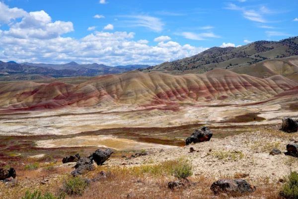
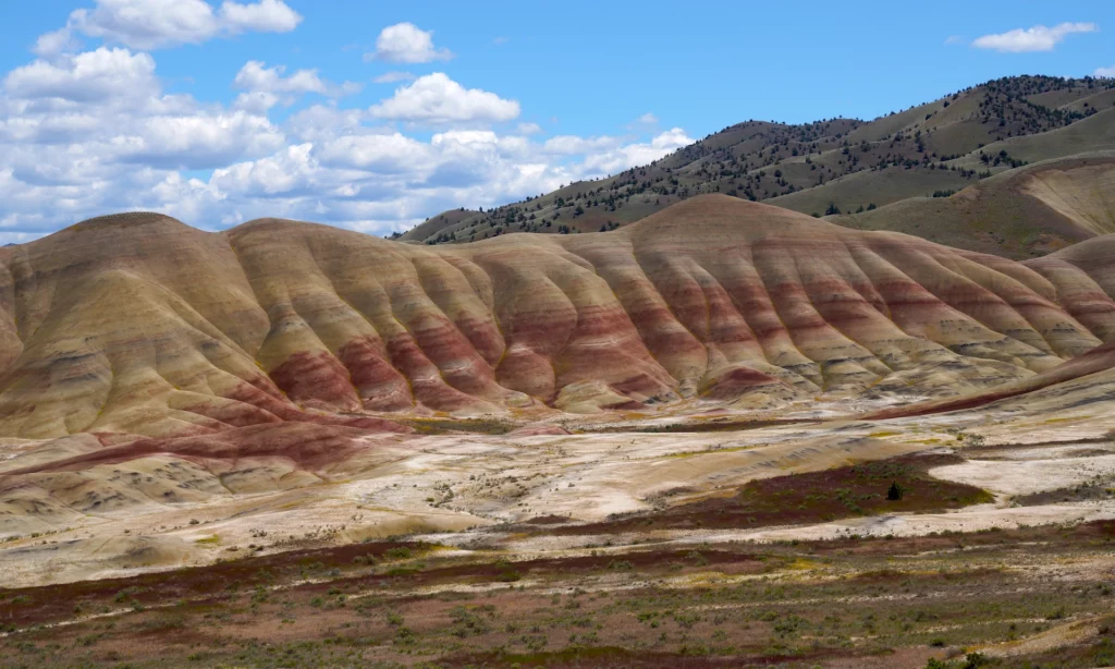
Painted Hills Unit
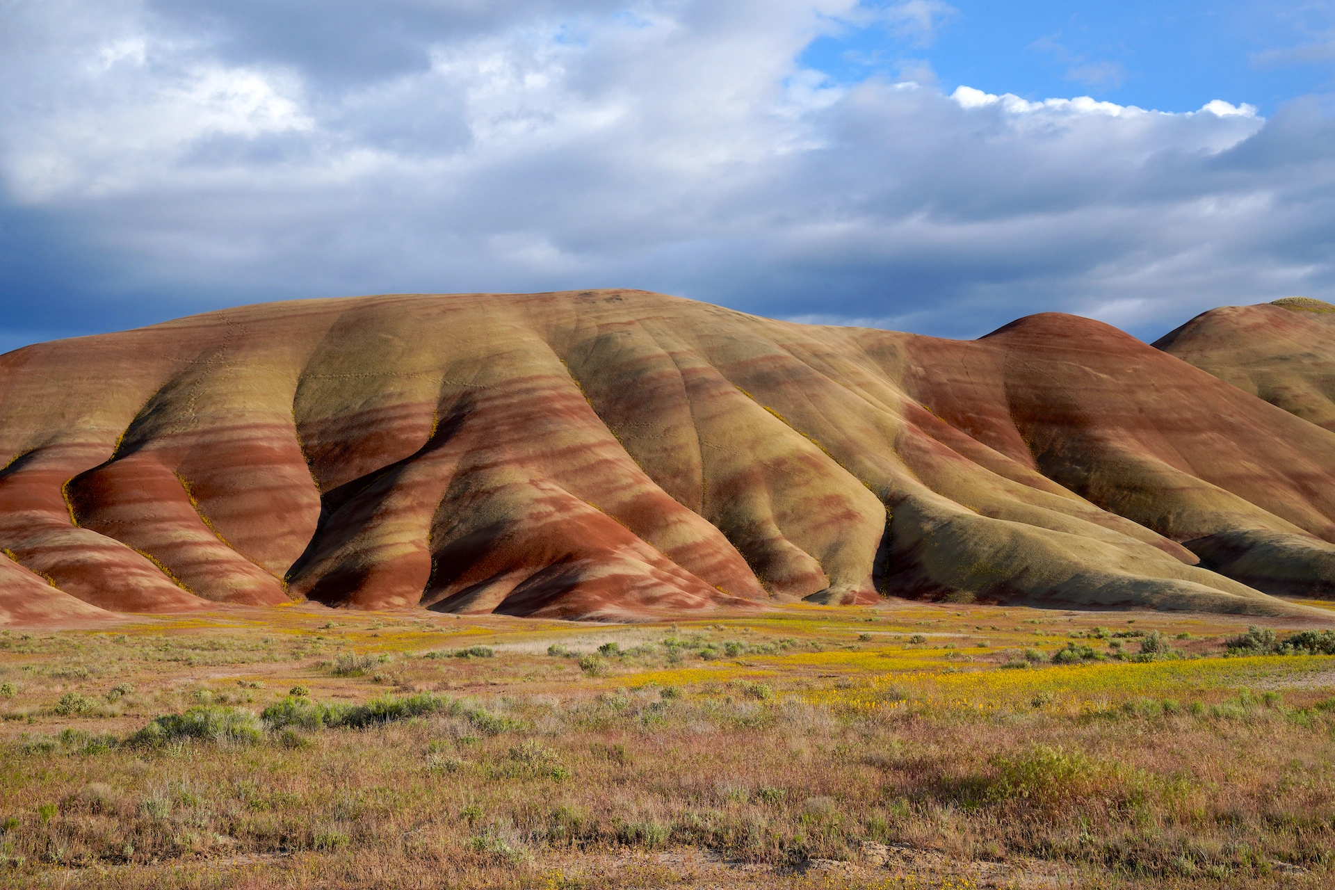
Painted Hills is by far the most famous and also the most popular unit of John Day Fossil Beds National Monument. With it’s brightly colored mineral clay stripes seemingly painted across the faces of undulating hills, Painted Hills is truly a site to behold. To my knowledge there are only a handful of locations like this on the planet, and at each the colors are different. Here you will find burgundy and brick reds, tan, white, and a little black. When we visited in mid-spring the addition various fresh greens, yellow balsamroot flowers, and vast stretches of pinot noir purple grass rounded out the palette. The coolest part about it is the level of change in the colors as the day progresses – it looks quite different at different times of day. Painted Hills is perfect for families and pets and is truly a must for photographers. With five easy trails and a verdant picnic area by the creek, Painted Hills will no doubt be a place you will be glad you experienced. I would give this incredible park a 10/10 if it had a few more trails. I left wanting to see more and see it from additional angles.
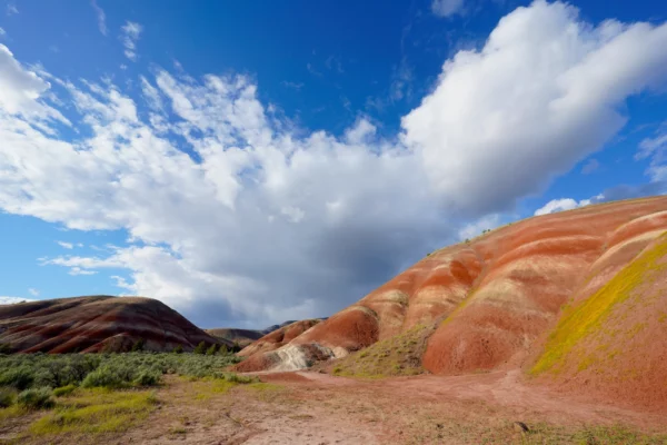
Dramatic clouds appear to burst out from behind hills striped with orange and white claystone at Painted Hills.
Painted Hills Cloudburst
Dramatic clouds appear to burst out from behind hills striped with orange and white claystone at Painted Hills in eastern Oregon. We stumbled upon this amazing scene in late afternoon after visiting the Sheep Rock Unit to the east. This exact hill formation is a few miles down the road outside of the official Painted … Read more
Painted Hills Picnic Area
As you approach the unit you will pass a few good striped hill formations on the right and may have to brake for cows in the road (beware!) before turning left into Painted Hills via a dirt road. At the next intersection head left to reach the only restrooms (vault toilets) and the picnic area plus a small info kiosk. The thing that is amazing about this spot is how absolutely opposite it is from the rest of the unit. It’s really green, with leafy trees casting welcome shade onto the picnic tables scattered across the rich lawn as a brook babbles nearby. It’s definitely a few degrees coolor here and the trees also help break the wind. This is a great spot for lunch or for a break from exploring, and everything here is handicapped accessible.
Lower Painted Hills Viewing Area
As you head toward the trails, be sure to pull out at the parking area on the left before the road starts to climb. The view from here is fantastic. No hike, just jump out of the car. For folks with mobility issues this is a great spot. This spot is not signed but you can’t miss it. There are a few other small turnouts / wide shoulders as the road climbs for quick snaps from different angles.
Late afternoon sunlight casts shadows across the gently-wrinkled face of Painted Hills. You literally drive right up to this view, which is found at the unsigned lower / first parking area.
Painted Hills Shadow Play
This is the first, and perhaps my favorite, view of Painted Hills as you enter the unit. This section of the formation in particular looks like the hills are melting. The interplay between the shapes in the hills and the striking strokes of red is an awesome sight! In this shot the gentle curves in … Read more
Carroll Rim and Painted Hills Overlook
At the top of the rise turn left into this area. Park immediately on the right (only space for 3-4 vehicles) for Carroll Rim Trail or continue to the larger parking area for Painted Hills Overlook and Carroll Rim overflow parking.
Carroll Rim Trail
- Trail Length: 1.6 miles total (0.8 miles each way)
- Trail Type: out and back
- Hike Time: 45 – 60 minutes
- Trail Difficulty: moderately easy 4/10
- Elevation Gain: 374 feet
- Trail Surface: dirt and gravel
- Popularity: 5/10
- Family friendly: yes
- Pet friendly: yes
- Handicapped Accessible: no
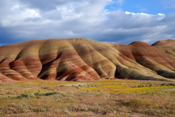
Carroll Rim Trail starts directly across the main road from the parking area and heads up the side of a bluff/ridge and then across the fairly flat top. The views are tremendously good and constantly changing, with a few obvious viewpoints en route. From the primary viewpoint at the end of the trail a panorama opens up with astounding views of the main Painted Hills formation plus so much more. Breathtaking! Photographers could spend half a day or more on this one trail. Be careful with kids on this trail as the dropoffs get big. The trail is fairly thin in spots so be courteous and allow others to pass.
The overall grandeur of Painted Hills is on full display when viewed from the Carroll Rim Trail.
Painted Hills Grandeur
Painted Hills is one of the most epic and unique places I’ve ever been. I hiked a ways up the Carroll Rim Trail to really get a sense of the scale and grandeur of the whole formation, stopping where the trailside black lava chunks added some foreground interest to the scene. I love the surprisingly … Read more
Painted Hills Overlook Trail
- Trail Length: 0.6 miles total (0.3 miles each way)
- Trail Type: out and back
- Hike Time: 20-30 minutes
- Trail Difficulty: fairly easy 3/10
- Elevation Gain: 82 feet
- Trail Surface: dirt and gravel
- Popularity: 6/10
- Family friendly: yes
- Pet friendly: yes
- Handicapped Accessible: partially yes
When you see photographs of Painted Hills, most are taken from this trail or from the overlook at the trailhead, or even from the parking lot. I honestly would challenge anyone to not be astounded by the unique beauty of this place. It just doesn’t get any better than this!
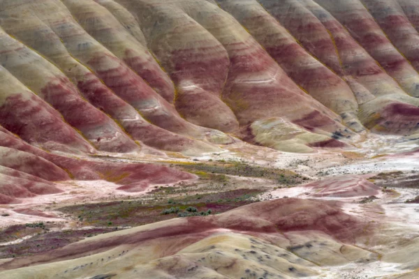
The combination of colorful strips and sinuous layers of hillsides make Painted Hills a one-of-a-kind sight to behold.
Burgundy Brushstrokes
Sinuous layers of drainages fill with yellow springtime balsamroot flowers in this beautifully vivid section of Painted Hills. Just looking closely at one part of Painted Hills is perhaps more awe-inspiring than looking at the entire formation at once. The angle and strength of the sun really changes the look of things here, which is … Read more
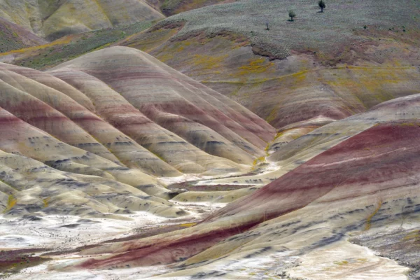
Patches of yellow balsamroot flowers add yet another color to the already beautiful Painted Hills.
Painted Hills Details 3
Painted Hills are an incredible sight, especially when focusing on the details. The yellow balsamroot flowers add yet more color to this already beautiful landscape, and the trees in the sagebrush desert help give a sense of scale to the photo.
The trail follows a ridge line with the main Painted Hills formation on the left and more incredible scenery on the right, rising in bursts to a higher overlook at the end. The first section of the trail is essentially flat and is handicapped accessible, and also has the best views of the formation in my opinion. For those with mobility issues I recommend turning around once you reach the steeper section of the trail. The view looking south from the parking area is not of the main formation but is quite good as well, and for sunset there is a wonderful spot looking over the rolling hills at the opposite end of the parking area from the trailhead. This is another place where a photographer could wind up spending half a day without blinking an eye.
While there are no campgrounds at any of the three units, the trails are open for night hikes and stargazing. Painted Hills Overlook seems to me the best location to check out the heavens as its up on a ridgeline with no trees to obstruct the view. On a full moon night I imagine the silver light on the striped hills would be just unreal.
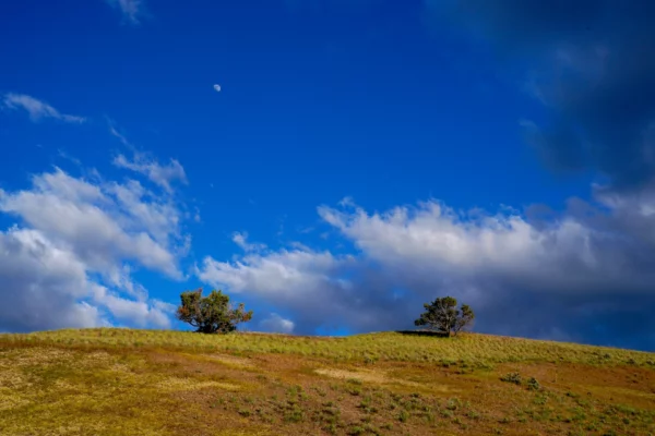
Two trees rise above the ridgeline beneath a deep blue sky at the end of Painted Hills Overlook Trail.
Two Trees
When you visit a place like Painted Hills Unit in John Day Fossil Beds National Monument it’s hard not to focus on the epicness of the main features at each location. It’s when you slow down and take a good look all around that you start to notice how amazing everything is and not just … Read more
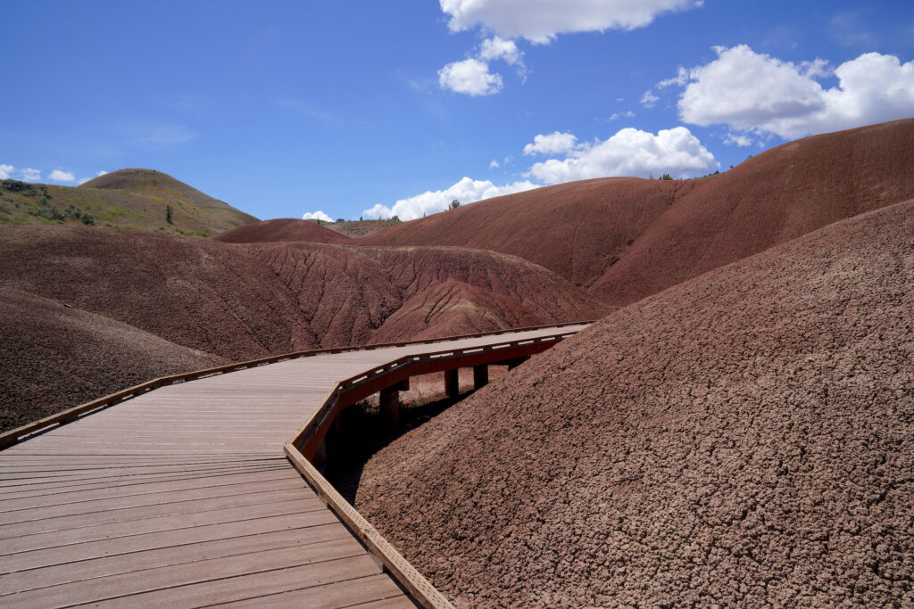
Painted Cove Trail
- Trail Length: 0.25 miles total
- Trail Type: loop with extension
- Hike Time: 7-15 minutes
- Trail Difficulty: fairly easy 3/10
- Elevation Gain: 42 feet, 70 with extension
- Trail Surface: boardwalk, dirt and gravel
- Popularity: 6/10
- Family friendly: yes
- Pet friendly: yes (make sure boardwalk is not hot)
- Handicapped Accessible: yes on boardwalk
Painted Cove is another of this unit’s star attractions. Here visitors can get up close with the red clay soils on the gracefully-constructed boardwalk that winds through this small formation. You can take the loop either direction, but it’s the boardwalk area that is clearly the gem. A 0.1 mile trail extension leads up a few sets of steps to some viewpoints of the Painted Cove formation with a small lake in the distance. The views looking east to Carroll Rim and west across the valley are also quite good. Do not walk on the sensitive soils – stay on the boardwalk and trail please! Expect to see some photo shoots, family pics, and models in summer dresses here. Everyone wants their pictures taken here! As a nature photographer I found the Painted Cove formation itself to be less interesting than some of the other trails in this unit. By mid-afternoon expect the high bluff to the west of Painted Cove to cast its shadow across the entire formation, which changes the entire look of this spot. Early morning is actually be the best time to get good sun and shadows on the scene. Exploring this trail takes about half an hour if you stop and check things out, possibly longer if its busy and you’re waiting for the sweet portrait spot on the boardwalk.
The boardwalk gets hot in the sun even when the temperatures are mild. Check it first before you walk your dog on it. Burned paws are no fun!
Painted Cove is well signed. Continue west past Painted Hills Overlook, then right at the next intersection. The parking areas are on both sides of the road in 1/4 mile. The road and lake beyond Painted Cove is private property and is clearly marked as such.
Leaf Hill Fossil Trail
- Trail Length: 0.25 miles
- Trail Type: loop
- Hike Time: 5-10 minutes
- Trail Difficulty: fairly easy 3/10
- Elevation Gain: 30 feet
- Trail Surface: dirt and gravel
- Popularity: 4/10
- Family friendly: yes
- Pet friendly: yes
- Handicapped Accessible: no
Leaf Hill Fossil Trail is a short loop hike through small junipers and pines around a small hill littered with fragments of leaf fossils. The area was heavily excavated with finds from this site on display at the Thomas Condon Visitors Center. A series of interpretive signs illustrate what was found here and how it was formed. The view across the desert is pretty good next to the hill, but overall this location is the least exciting for photography. There are a lot of birds here due to the trees. The trail is mostly flat but has one steeper up and down section right next to the hill. For those with mobility concerns, go right where the loop splits for the easiest way to get to the fossil area which is at the halfway point of the loop. Expect to spend half an hour here if you check out all of the displays.
From the Painted Cove intersection, head straightforward and follow the main road as it bends left, then find the small parking area on the right within 2-3 minutes drive. We caught a quick glimpse of a herd of deer on the drive to the this trailhead. Continue past to reach Red Hill.
Red Hill Trail (Red Scar Knoll Trail)
- Trail Length: 0.4 miles (0.2 miles each way)
- Trail Type: out and back with extension
- Hike Time: 10-20 minutes
- Trail Difficulty: easy 2/10
- Elevation Gain: 39 feet
- Trail Surface: dirt and gravel
- Popularity: 3/10
- Family friendly: yes
- Pet friendly: yes
- Handicapped Accessible: no
Red Hill Trail, aka Red Scar Knoll Trail, was a surprise highlight of our time at Painted Hills. We visited this striking little gem twice, hidden away at the far corner of the unit. There are no signs for this newest trail until you approach Leaf Hill just down the road. At the trail fork, go left for a fantastic view of the knoll’s red face which glows in the light as sunset approaches, or go right to walk around to the knoll’s tan face and to a gorgeous view of the rolling desert valley. If you’re there for nature photography, there’s a view of the knoll from the road that’s quite good as well, with spring wildflowers in the foreground. If you’re showing up in the evening and you’ve got limited time, skip Painted Cove and Leaf Hill in favor of Red Hill. With the right light a photographer could spend at hour or more on this trail.
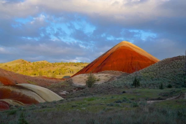
The last rays of sun illuminate aptly-named Red Hill as the desert around it sinks into shadow.
Red Illumination
The last rays of sun touch aptly-named Red Hill as the desert around it sinks into shadow. When we arrived at Red Hill Trailhead, tucked away at the far end of Painted Hills Unit of John Day Fossil Beds National Monument, the sun was moving out of the scene very quickly. I raced down the … Read more
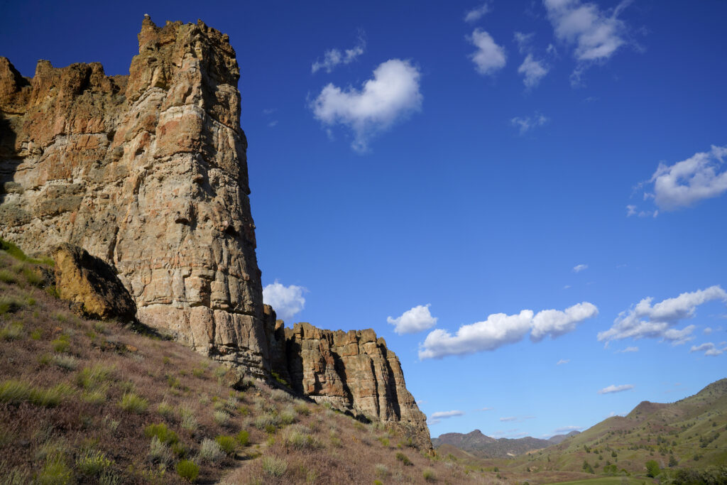
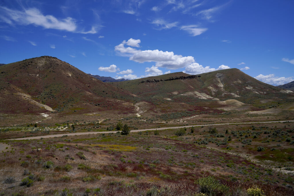
Clarno Unit
Clarno is the least visited of the three units of John Day Fossil Beds National Monument, partly because the other two units are closer together and much larger. Clarno offers towering cliffs studded with fossils, carved by the elements into an undulating line of spires and pinnacles known as The Palisades. When silhouetted against the early morning or late afternoon sky, the formation resembles the outline of a stalwart Medieval castle ruin. Three trails explore the cliffs and the rubble beneath them, with a very clean and rarely used day use area in a little desert glen just east of the cliffs. At the day use area you’ll find vault toilets (virtually unused), some pleasant picnic shelters with nice views, and plenty of parking. When we visited on a Monday evening we were the only people in the entire unit. The picnic area facilities are all handicapped accessible and looked fairly new.
The Palisades face south so expect intense sun and heat if you visit in the middle of the day in the high season. For photographers (and in general) the best times of day to vist are earlier in the morning or later in the evening when the sun and shadows play in the alcoves and outcroppings. Clarno is the best unit of the three to see fossilized leaf impressions in the stone.
The roadside parking area on Hwy 218 is the best place to park if you’re hitting the trails – all three trails connect at this point, but there is no restroom at this parking area.
Geologic Time Trail
- Trail Length: 0.5 miles (1/4 mile each way)
- Trail Type: out and back
- Hike Time: 7-15 minutes
- Trail Difficulty: fairly easy 3/10
- Elevation Gain: 40 feet
- Trail Surface: dirt and gravel
- Popularity: 1/10
- Family friendly: yes
- Pet friendly: yes
- Handicapped Accessible: no
Geologic Time Trail connects the picnic area to the roadside parking area, passing by the east spire of the Clarno formation. If you parked at the picnic area, all three trails can be combined into one hike from here by taking Geologic Time Trail, then taking Clarno Arch trail once you reach the roadside parking area, then returning by taking the Trail of Fossils and then continuing back on the Geologic Time Trail – this entire loop is 1.3 miles and takes 30-60 minutes.
Trail of Fossils
- Trail Length: 0.25 miles
- Trail Type: loop
- Hike Time: 5-15 minutes
- Trail Difficulty: fairly easy 3/10
- Elevation Gain: 60 feet
- Trail Surface: dirt and gravel
- Popularity: 1/10
- Family friendly: yes
- Pet friendly: yes
- Handicapped Accessible: no
Trail of Fossils leads up through the boulder field at the base of the cliffs where leaf prints from ancient flora are clearly visible in the rocks. Go right on the Geologic Time Trail, then left at the junction (signed for Trail of Fossils). The trail winds through the boulders, with a few informational displays scattered along the journey. If discovering fossil prints is your idea of a good time (or your children’s) then this otherwise quick hike could become a more involved treasure hunt. Just don’t take any fossils home! The trail leads back to the parking area at it’s conclusion.
Clarno Arch Trail
- Trail Length: 0.5 miles total (1/4 miles each way)
- Trail Type: out and back
- Hike Time: 20-40 minutes
- Trail Difficulty: moderately easy 4/10
- Elevation Gain: 249 feet feet
- Trail Surface: dirt and gravel
- Popularity: 1/10
- Family friendly: yes for older kids
- Pet friendly: yes
- Handicapped Accessible: no
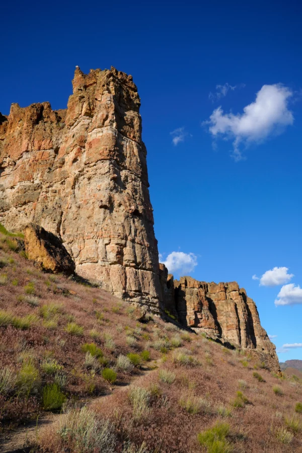
The cliffs, pinnacles, and alcoves at John Day Fossil Beds’ Clarno Unit are filled with fossils of leaves from the forest that grew here millions of years ago. This view is looking east from the switchback corner partway up the Clarno Arch Trail.
Clarno Palisades
Layers of times long gone are revealed in the stone at Clarno. The dramatic cliffs are filled with fossils from over 170 species that resided here millions of years ago. The pinnacles and alcoves of The Palisades resemble a Medieval castle. I especially liked this view from the trail heading up the desert slope to … Read more
Clarno Arch Trail starts on the left at the trailhead, ascending through the boulders then along the base of the cliffs. The views on this trail are fantastic and more varied than on the other two trails, with some visible fossils thrown in as a bonus. The trail ends at an alcove where water bore a hole through a weak point in the top of the cliff over millions of years, creating the arch. There’s a little spur trail to another alcove with flat rock benches which is a cool spot to hang out for a moment. Of the three Clarno Unit trails, this was by far the best one overall.
Getting There
Both Painted Hills and Sheep Rock are located off Hwy 26 in Central / Eastern Oregon. Hwy 26 runs from the Pacific Ocean near Cannon Beach all the way to Boise, passing through Portland and over Mt Hood en route. Painted Hills is 9 miles NW of the town of Mitchell. Sheep Rock is on Hwy 19 just north of the junction with Hwy 26, between Dayville and Kimberly. The Clarno Unit is north of Painted Hills on Hwy 218 around 20 miles west of the little community of Fossil.
The drives are fairly far between the three units, and all three are a good distance away from any larger towns. Distances and travel times between units are:
- Painted Hills to Sheep Rock: 45 miles (1 hr) via Hwy 26
- Painted Hills to Clarno: 70 miles (1 hr 30 min) via Hwy 209, Hwy 19, and Hwy 218
- Sheep Rock to Clarno: 89 miles (2 hrs) via Hwy 19 and Hwy 218
From Portland it takes 4 hours to reach Painted Hills and five to reach Sheep Rock via Hwy 26, passing through Prineville. From Bend it’s 1 hour 45 minutes to Painted Hills on Hwy 26 via Prineville. From Boise its 4 hours to Sheep Rock and five to Painted Hills on Hwy 26 via Ontario and John Day.
The Clarno Unit is 3 hours 15 minutes from Portland via Hwy 26 to Hwy 218, and 1 hour 45 minutes from Bend via Hwy 97 to Hwy 218. From points east the fastest way to Clarno is to pass through the Sheep Rock Unit – its 5 hours 30 minutes from Boise using this route.
For Painted Hills, turn north off of Hwy 26 (left if coming from points west, right from points east) onto Burnt Ranch Road and continue for 9 miles. Turn left onto Bear Creek Rd where the pavement ends and enter the unit. The locations for Sheep Rock unit are directly on Hwy 19. Similarly, Clarno is directly on Hwy 218.
A Day At John Day: Itineraries
With so much to see spread out over such a broad area, seeing everything in one day is a full-day challenge that’s only possible in May – July when there is a lot of daylight. Pack a picnic lunch and follow this route to see everything in the best conditions:
- Arrive at Clarno Unit 8:30 – 9:00AM.
- Depart Clarno Unit at 10AM, drive to Sheep Rock Unit.
- Have lunch at Foree at noon (your first location in Sheep Rock) then work your way south to the other Sheep Rock locations. Skip Blue Basin Overlook Trail.
- Be at the Thomas Condon Visitors Center by 3pm.
- Skip Mascall Formation and depart Sheep Rock at 4pm and head toward Painted Hills.
- Have early dinner or happy hour at Mitchell Brewery in Mitchell, near Painted Hills at 5pm.
- Arrive at Painted Hills by 6:30 and explore, then head home. There are food options open in Prineville until 10pm.
Too much? Cut Clarno Unit out of your itinerary. Visit Sheep Rock first, then Painted Hills.
The way to see it all at a more in-depth and relaxed pace is to plan a multi-day visit.
Lodging
While I do not normally include lodging in location articles, this area is both vast and remote so planning lodging ahead is important. There is very little in terms of hotels and inns in the immediate vicinity of John Day Fossil Beds – Prineville & Madras (west) and John Day & Mt Vernon (east) have your closest good options. We stayed at Country Inn & Suited by Radisson, which was perfect – four pet friendly rooms, indoor pool, and a surprisingly good breakfast included. Best Western is another nicer option in Prineville. If you’re on a budget there’s an Econolodge. There are some cabin rentals available much closer to all three units.
There are no campgrounds within any of the three units, but there are campgrounds throughout the greater area. At Painted Hills we looked around at camping options, and there is an unnamed dispersed camping area in a field next to the creek about three miles south of the turn into the unit. Priest Hole, Burnt Ranch, Hidden Springs, Ochoco Divide, and Wildwood are all established campgrounds within a reasonable distance. For Sheep Rock there is not as much camping – your closest campground is Lone Pine Campground just north of Kimberly. For Clarno, check out Bear Hollow Park southeast of Fossil.
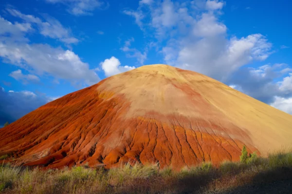
The side view of Red Hill reveals more of the smooth golden clay layer which tops the knoll.
Red Hill 6
Red Hill was a surprise to me when I visited Painted Hills in May 2024. It’s just not a feature that is photographed or promoted as much. Red Hill turned out to be one of my favorites, especially when the light came in from the side in late afternoon accentuating the textural difference between the … Read more
Cautions
Central and Eastern Oregon are quite different than the what most folks think of when they think of Oregon. This is a harsh landscape of extremes. Knowing what to expect and being prepared are important when visiting John Day Fossil Beds National Monument.
Services
First, there are very few services here. Expect to not have cell service or internet access at most locations. Fuel up in Prineville, Maupin, or John Day before heading here. If you’re driving an EV, make sure you know where charging stations are and if they are currently functional – I drive a Chevy Bolt (which has a standard charge connection) and so I use the Chevy app or the ChargePoint app. John Day Fossil Beds is a long way from anything, with over an hour drive between units along winding rural highways.
There are only a few stores or restaurants nearby (with sporadic hours especially in the cold season) so making a plan for meals and bringing some food and beverages is a really good idea. There are no official park concessions in any of the three units.
Environmental and Physical Considerations
Second, you’re traveling into semi-arid, open country. There is very little shade or cover from times of extreme conditions. Summer sun can be especially intense and temperatures can soar into the triple digits. Wear sunscreen and bring plenty of water. Check the weather forecast for Mitchell (Painted Hills), Dayville (Sheep Rock) or Fossil (Clarno) before heading out so you know what to expect. Temperatures can plummet severely at night. Strong, dry winds are possible as well – a windbreaker jacket makes a lot of sense, and face & eye protection is a good idea if dust is blowing. There’s a strong chance of forest fire smoke hazing out the views and making it hard to breathe from July until fall rains return.
In winter its important to stay hydrated, protect from windburn, watch for potential ice on trails, and keep an eye on the sky so you know to head back to the car if a storm is advancing your way. The spring and fall shoulder seasons are the most pleasant times of year to visit, with mild daytime temperatures and generally fair conditions. When we visited in May 2024 the conditions were absolutely perfect.
Most of the locations in the National Monument are fairly flat and do not pose any risks associated with falling or sliding. The following trails are the few where trailside dropoffs that could result in injury exist:
- Sheep Rock: Blue Basin Overlook Trail, Flood of Fire Trail
- Painted Hills: Carroll Rim Trail
- Clarno: Clarno Arch Trail
Beware of highway traffic if you stop at a roadside turnout in Picture Gorge along Hwy 26.
Wildlife
Last, there is a lot of life here even though it may not appear so at first glance. Be aware of it. Western rattlesnakes inhabit all three units – the boulders at Clarno are prime habitat. Rattlesnakes are most active in the late afternoon. Night snakes are around as well, but they are not venomous or aggressive and will only be out at dusk and dawn.
Ticks are a faint possibility in spring in the brush and grass – stay on the trail to avoid them, and wear long pants for protection. There are also wasps and biting flies, black widow spiders (rare) and scorpions (also rare). Mosquitos are possible around areas of water. When we visited we did not have problems with any of these critters, other than a big hornet landed on me at Painted Hills (it was not aggressive and I did not get stung) and I saw a busy honeybee hive off the side of the Clarno Arch Trail way up near the end of the trail (similarly the bees did not bother me at all as I walked past twice).
Also watch out for cows on the road at all times. Some are free range or maybe they just escaped??? Deer and elk could be driving hazards as well. There are larger predators throughout Oregon like coyotes, mountain lions, and black bear, but encounters with these elusive creatures (even just seeing one) is extremely rare within the National Monument. The area is not a high population density zone for any of these animals. The mammals you are most likely to catch a glimpse of are deer, pronghorn antelope, and jackrabbits. Raptors like red tail hawks and turkey vultures are common. We also saw a lot of magpies and dozens of species of songbirds.
Poison oak is not present in this area. Hooray!
Photographers Tip
Bring a full range of lenses. I found myself using a wider lens more frequently than I usually do. If you want to get details of the primary Painted Hills formation you need a zoom lens because you are not able to get close to it. My advice is to visit in spring when yellow Balsamroot flowers trace the drainage gullys down the hillsides.
Part of the beauty of the area is how far the view goes on for. The daily shifting angles of sunlight feel exaggerated – the sun and shadow interact with the colors in very cool ways. When we visited in May there were wonderful puffy clouds throwing their splotchy shadows across the landscape and causing me to have to constantly change my camera settings. At Painted Hills, look beyond the obvious and explore beyond Painted Hills Overlook. At Sheep Rock I found Cant Ranch to be surprisingly photogenic. The Clarno Arch Trail was the clear ace at the Clarno Unit.
I’ve also heard that the colors in the claystone formations become brighter when wet, which makes sense.
Links
https://www.nps.gov/joda/index.htm
https://www.oregonencyclopedia.org/articles/john_day_fossil_beds